Back to Garcia Trail Page
Garcia Trail / Azusa Peak (2081')
Azusa / Los Angeles County
Angeles National Forest / Southern California
Below is a running archive of the notes I have posted concerning the trail conditions of Garcia Trail.
Trail Notes Archive:
- Bench on Azusa Peak - 10-23-11: Sometime in the last few months somone installed a brown wooden bench on the peak.
-
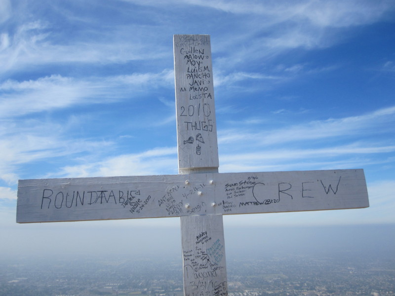
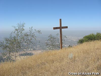
Cross on Azusa Peak - 8-1-10: Since the cross was erected in February 2007, it has continually evolved. The original branding is long gone and the various signatures, sayings, scriptures, and assorted comments come and go. At one point someone affixed some tacky solar-powered lights to the cross. Thankful they are gone. Since February 2010, someone completed painting the cross white. Someone also attached a white mailbox to the cross containing a summit logbook—the first entry was 4-16-10. The first book filled up quickly and a second book has been started. The cross has become an iconic fixture on Azusa Peak.
-
Rattlesnakes - 8-10-08: While on top of Azusa Peak, I was chatting with a women who asked if there were rattlesnakes in the area. I replied that snakes are a natural part of these mountains, but rarely does anyone get bit, and that I don't recall seeing a rattlesnake on this trail for at least a decade. Than when I started down the trail a man hiking up told me he just encountered a big rattlesnake in the lower section of the trail. He marked the location with a stick across the trail. As I continued down, I met another hiker who was stopped. He pointed out a rattler next to the trail. The snake was coiled in the dry plants and rattling vigorously. He crawled away and we safely passed. Then near the bottom of the trail we came across the stick that the other hiker had placed across the trail, and there was clearly a snake track across the trail. I have no way of confirming if that one was indeed a rattler, but the presence of a rattlesnake further up the trail certainly reinforces the fact that the venomous creatures are present. However, don't let that deter you from hiking. Just be alert, and if you come across a snake, simply give it room to safely crawl away.
-
Cross on Azusa Peak - 2-12-07: On the Presidents' Day Holiday, Monday, February 12, 2007, a large wooden cross was erected on the top of Azusa Peak. It was marked with "BBB, Braves Baseball" and had the signatures of players and their jersey numbers. It was built with 4x10 timbers and stands approximately 15 feet tall. At the crossbar is a metal plate with the inscription: "Mat 16:24 He must deny himself, take up his cross & follow me."
- Sierra Madre Avenue now open - 8-10-08: For a about two years Sierra Madre Avenue had been closed in conjunction with the construction of the Rosedale housing development. The project entailed rerouting Sierra Madre Ave., curving to the south and back.
- Cross on Azusa Peak - 2-12-07: On the Presidents' Day Holiday, Monday, February 12, 2007, a large wooden cross was erected on the top of Azusa Peak. It was marked with "BBB, Braves Baseball" and had the signatures of players and their jersey numbers. It was built with 4x10 timbers and stands approximately 15 feet tall. At the crossbar is a metal plate with the inscription: "Mat 16:24 He must deny himself, take up his cross & follow me."
- Closure Notice - Update 7-10-06: Sierra Madre Avenue is now closed west of the Garcia Trail trailhead. The closure is in conjunction with the construction of the Monrovia Nursery housing development, named "Rosedale." The project entails the rerouting of Sierra Madre Blvd., curving to the south and back. You can still access Garcia Trail by driving north on Barranca Avenue to Sierra Madre Avenue, turn left (west), drive past the closure signs (still open for local traffic assessing the houses in that area), and drive 0.5 mile to the Azusa boundary where the signs forbids you to drive further. Park in front of the house and proceed up the trail as usual.
A front-page article in the San Gabriel Valley Tribute (7-9-06) stated that the road will be closed for six months. The map caption with the article stated it will be closed for nine months (Oops...proofreading!). A previous sign at the trail listed the following contact information: Azusa Land Partners' project coordinator, Regina Fielder, at (949) 729-1202.
As part of the project, the fire station will be moved a short distance away and a new trailhead for Garcia Trail will be built, including a parking lot. Early in 2006, the construction caused a couple slight detours on the trail. At the beginning of the hike, the trail has been shifted over about 20 feet to the right. And about 5 minutes up the trail, a switchback has disappeared and fenced off, forcing a temporary path straight up the slope, about 15 feet. From this point you can see the massive amount of work below to carve a huge cavity for the water tank. Both detours are a little steep and slippery, so watch your step. Steps carved out of the dirt help. The grading on the housing project is well underway.
-
 Bee Alert - 6-10-06: Around December 2006 someone posted a sign warning about bees. When I hiked Garcia on 3-10-06 I saw no bees. However, on 3-28-06 Mandy reported, "about three quarters of the way up the trail, there is a swarm of bees like a cloud that you have to pass through." On 6-10-06 I encountered no bees while hiking up (cool, cloudy), but when coming down, I found the bees (10:20 a.m.). The colony is in the cleft of rock at ground level right next to the east side of the trail (about half way between D and E on the aerial photo above), marked with a pink tape. I passed by without incident. On 9-21-06 there were very few bees, probably since there were virtually no flowers in bloom. There was no bees present on 6-30-07
- Mountain Lion Alert - 6-8-06:
Maria writes: "We hiked Garcia Trail today (6/8/06) and on the way down, we spotted a young mountain lion right on the trail just a few yards from the trailhead. It was on the last switchback where you can see the fire station. As soon as he heard us he turned around, saw us and turned away running into the bushes right above the fire station."
Earlier this year a sign at the trailhead read: "A mountain lion was seen 1-4-2006 on the Garcia Trail." I wonder if it was the same lion that was spotted on nearby Van Tassel fire road on October 22, 2005. Personally, I would not discontinue using a trail because of such a wild animal sighting, but I have to admit that I'll be more alert. Read news story about mountain lions (11-9-05) and what to do if you encounter one.
|
Attention Hikers
Beginning June 1, 2005. Portions of the Garcia Trail will be subject to periodic closures due to grading and construction of a new City of Azusa water reservoir by Azusa Land Partners, LLC.
Trail areas impacted by construction activities will be clearly marked with construction fencing and will be off limits to hikers. Please use caution and common sense when using the trail. Construction of the reservoir is scheduled to be completed by September 2006.
In case of an accident or emergency, please call 911. For all other questions, please contact Azusa Land Partners' project coordinator, Regina Fielder, at (949) 729-1202.
For posting April 25, 2005
|
-
Closure Note - Update 6-26-05: The notice at the right is posted at the trailhead. It is in conjunction with the construction the Monrovia Nursery housing development, named "Rosedale." The project also entails the rerouting of Sierra Madre Blvd., curving to the south and back. The fire station will be moved a short distance away and a new trailhead for Garcia Trail will be built, including a parking lot. As of 6-26-05, Garcia Trail is still open.
-
Trail Conditions - Update 6-26-05:
The winter rains caused quite a bit of erosion on the trail with ruts running down the middle of the trail in many places. So watch your step. It does not look like any formal maintenance has been done on the trail since before the rains. The mustard and other weedy plants have invaded much of the trail space. Some brush clipping has been done recently, but obviously by amateurs — they left the clippings right where they fell rather the tossing them down the slope and out of sight. The washed out section near the top of the trail has been negated by the sheer foot traffic.
-
Bee Alert - 3-28-06: A few months back someone posted a sign warning about bees. When I hiked Garcia on 3-10-06, there were no more bees. However, Mandy reports today, "about three quarters of the way up the trail, there is a swarm of bees like a cloud that you have to pass through." So, beeware.
-
Trail Conditions - Update 3-10-06: Everything is green and the wild flowers are starting to bloom. The trail is still badly rutted in places — needs a full-scale restoration effort. A few months back someone posted a sign warning about bees. Now no more bees and no more sign.
-
Trail Conditions - Update 1-22-05: The December and January rains that pounded the Southland took their toll on the San Gabriels. With the mud slides having forced the closure of many roads, I was curious as to how the rains affected the trail. So on Saturday 1-22-05, I headed up Garcia Trail to check things out. There are numerous places where mud has slid down unto the edge of the trail, but most don't hinder safe hiking. It's near the top where the real damage has occurred. As I neared the ridge-view point ("D" on the aerial photo), I came across a huge slide. It was about 20 feet wide along the outside edge of the trail and extended more than 100 feet down the slope (View photos). The scar is clearly visible from the city below, along with other slides on the mountainside. As I left the slide and rounded the bend, I couldn't believe my eyes. Tons of mud and debris had covered about a 25-foot section of trail. In the last two weeks since the rains, a use path has emerged detouring up and across the debris field. It can be negotiated safely, but obviously it will take a serious effort to restore the trail to normal condition.
 After I reached the ridge road, I headed east and hiked all the way to Glendora Mountain Road. There were numerous slides. The raw power of nature is mind boggling. Within about a mile from the GMR, a pair of tire tracks ended where a large tree had fallen on the road. In another minute east, the storm water had re-routed itself under the road and created a huge sinkhole, leaving a narrow bridge just wide enough for a vehicle. I was surprised that a truck had driven over it. It did not look safe.
When I reached the GMR, there was a continuous stream of dump trucks hauling dirt up the highway then heading down for more. After I had walked about a mile and a half down the road, a truck stopped and the driver asked me how I got there. When I told him, he was a little puzzled and made it clear that with all the truck traffic, I really shouldn't be there. "Well," I replied, "you want to give me a ride." He agreed and I enjoyed a truck ride all the way down to Sierra Madre Avenue. It sure saved me a lot of walking!
-
Hike note 1-22-05: In spite of mudslide damage, the mountains were beautiful and the weather pleasant. Everything was so green. I enjoyed wide panoramas of the back range covered with snow, from Twin Peaks to the north to Ontario Peak to the east. I encountered about 21 people in six parties on Garcia Trail - which is pretty typical, and a couple joggers on the Glendora Ridge Road. But as I traversed east alone the road, I was amazed that I had the whole mountain virtually to myself. Millions of people in the San Gabriel Valley, yet I enjoy remarkable solitude as I strolled along soaking in the beauty of the mountains and nature.
Garcia Trail Links on Dan's Hiking Pages:
 Garcia Trail History
 Dan's slide show
 Aerial photos
 Topo Map
 Dan's Hiking Blog:
- Garcia Trail Hike - August 1, 2010
- Garcia Trail Hike - January 1, 2011
- Plants on Garcia Trail - May 9, 2011
- Beginning Summer on Garcia Trail - June 21, 2011
Back to Garcia Trail Page
|