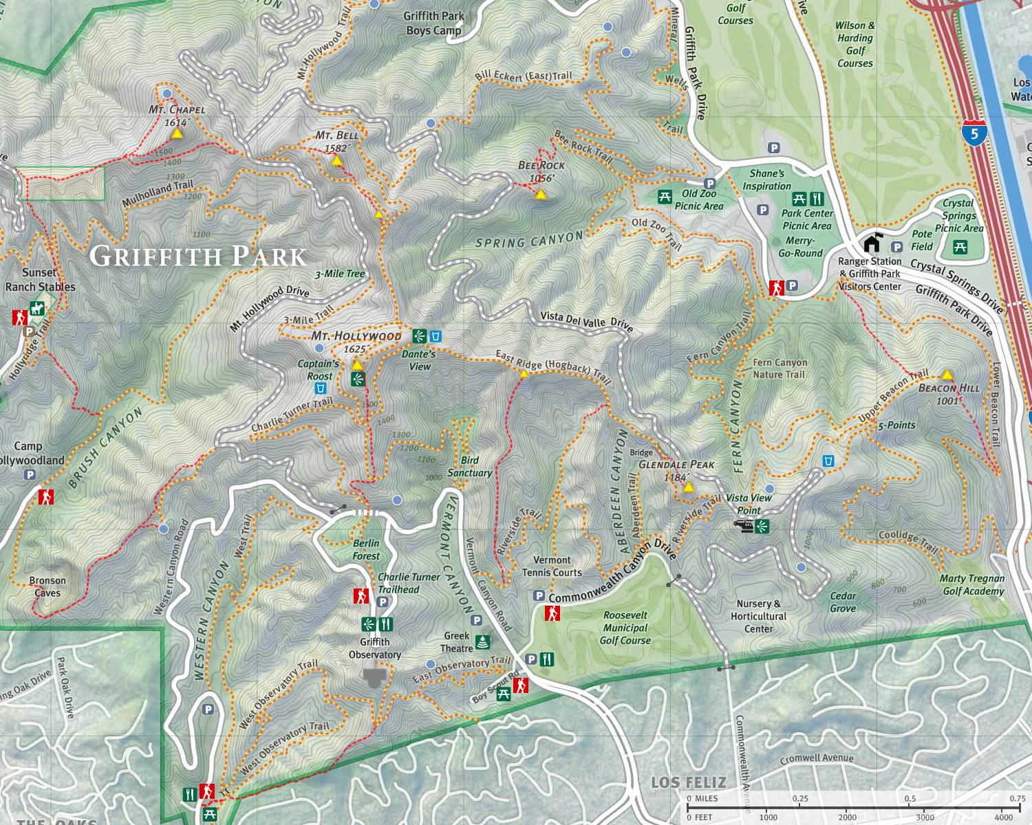
Glendale Peak, Hogback and Mt. Hollywood
Griffith Park / Los Angeles / Southern California
 Hike Report: April 30, 2010 Hike Report: April 30, 2010
 Glendale Peak Hike Description Glendale Peak Hike Description
April 2010 turned out to be Griffith Park month for me. On April 8 I climbed Beacon Hill and beyond. I so enjoyed it that on April 16 I hiked Bee Rock and Mt. Bell. Now I've climbed every peak in Griffith Park except for Glendale Peak, and I have not done the Hogback yet. I turned to my friend, John McKinney, for this hike. In Los Angeles Country: A Day Hiker's Guide, McKinney has a nice write-up for Glendale Peak as a 2.5 miles out-and-back. So I figured I could extend the loop to continue up Hogback Trail to Mt. Hollywood, then descend via Vermont Canyon. When the day arrived, I was delighted that weather was so beautiful...almost perfect.

|
|
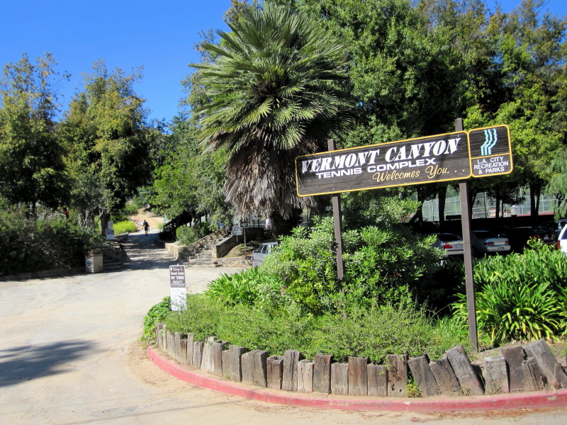
Trailhead: Vermont Canyon Tennis Complex on Commonwealth Canyon Drive.
|
3:17 p.m. - Leave my office in Echo Park driving north on Sunset Blvd. Turn right on Vermont and onward to Griffith Park. I deliberately pass my turn on Commonwealth Canyon Drive to clock the distance to the Bird Sanctuary (the route of my return). Then back to Commonwealth and to Vermont Canyon Tennis Facility and park. McKinney's directions were spot on.
3:45 - Start up the trail between the tennis courts heading north. The sun is warm and the hills don't seem as green as the last couple hikes...probably because I'm on a south facing slopes that were incinerated in May 2007, and the hills here are dominated by non-native grass that is browning. Pleasant grade. Looking east across the small canyon I can see my route heading east.
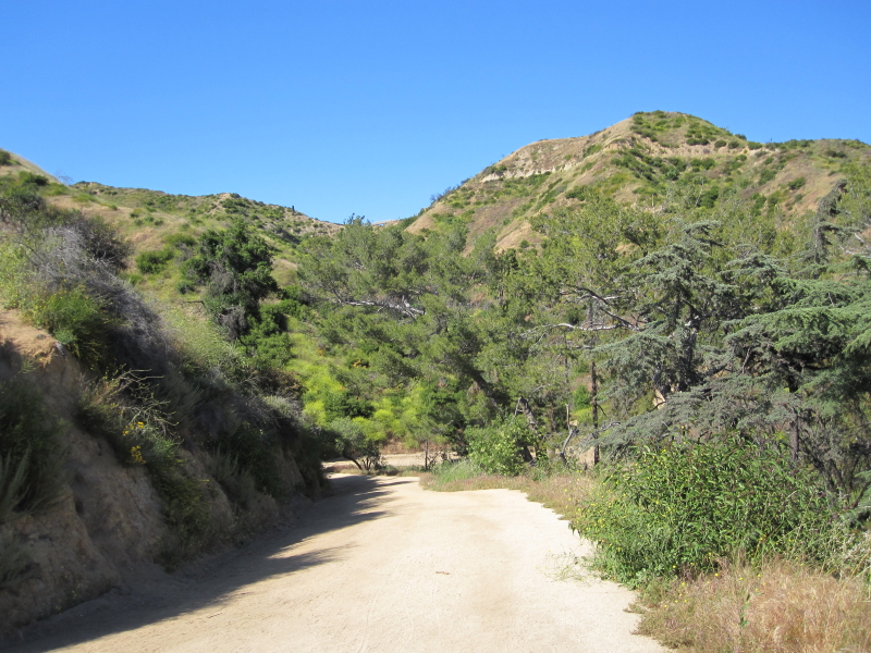
3:52 - Junction with Riverside Trail (don't know where it got its name...no river around). Can see hikers like ants on Hogback directly north. Turn right and begin heading east. Lots of evasive mustard in bloom. Soon the observatory appears over the ridge to the west. Mt. Hollywood then appears to the northwestÉmy final summit destination for day.
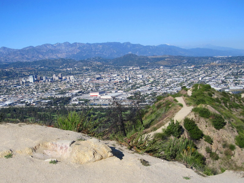
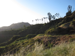
4:01 - Outward bend with great views of my beloved L.A. skyline. Lot of blooming flowers. Contouring into Aberdeen Canyon now. Glendale Peak, my first summit for the day, lies directly ahead. I can see the bridge on the Hogback. Going to be there soon.

|
|
On Riverside Trail looking northeast from Aberdeen Canyon toward Glendale Peak View Large Image.
|
4:05 - Junction - side trail to Commonwealth Canyon Drive (post #5), about 30 yards. Now climbing again.
4:09 - Round outside bend and have view east to Vista Del Valle Drive, where I was three weeks ago. Lots of blooming mustard colors the canyon with a yellow hue.
4:15 - Junction Vista Del Valle Drive and Hogback Trail. Look around. Great views now east toward Glendale. No one here. Last time it was pretty busy. Walk past the green pump shed (sign on the shed says "Bridle Trail") and head west along the south flank of Glendale Peak. Soon Mt. Hollywood comes into view. I'm loving the sun, breezes, flowers, and great views.
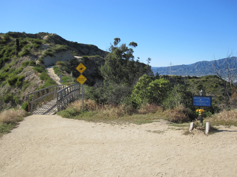
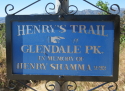 4:26 - Bridge and start of Henry's Trail. Linger taking pictures. Fun to see Fern Canyon Trail and Beacon Hill below. The sign reads, "Henry's Trail, Glendale Pk., In memory of Henry Shamma, 9/93." McKinney records that Shamma was a popular Sierra Club leader "who delighted in leading hiking groups to the summit and sharing the fabulous views."
4:31 - Turn hard right unto Henry's Trail and follow the narrow path southeast up the ridge. Thanks for the steps, Henry. Soon I can see the summit up ahead. Great views. Lots of foot traffic over on Hogback. None here though.
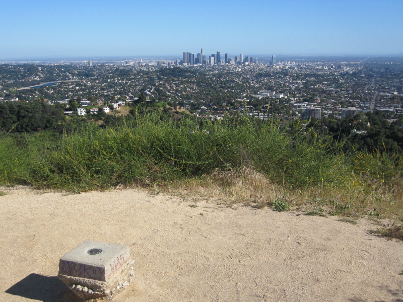
4:36 - Glendale Peak (1184'). Wow! Amazing views! I'm snapping lots of pictures. Soaking it all in. Pretty windy. Survey maker says, "Glendale, B10, 19." Makes a splendid short hike, but I have bigger ambitions for today. Leave peak at 4:46.
4:50 - Back at bridge. Start ascending Hogback ridge. Taking a lot of pictures, soaking in the scenery. Never alone for long. Spur trail heads down a finger ridge jutting south. Reach a steep pitch. Not bad going up, but could be slippery coming down. A little lady coming down chooses her steps carefully.
5:02 - Flat spot on ridge. See a group of equestrians higher up the ridge. Take video of helicopter. Look north toward Bee Rock and Mt. Bell where I was two weeks ago. Nice pics of horsemen riding down the ridge. Feels like a cowboy movie. They pass. They're armed with 45s. Oh, they're LAPD. Cool.
5:15 - "Hogback Peak" (1480'), as I call it. I Don't know why this prominent high point jutting up from the ridge does not have a name—it certainly has a strong profile ("Hogback Peak" seems like a good name for it. Purhaps in the future it could be dubbed Mt. LaBonge after City of Los Angeles Councilmember Tom LaBonge, who has been such a champion for Griffith Park). View East toward Glendale. A path comes up the ridge from the south, but it sure looks steep at the top. Start to head down west to meet the main trail but it's pretty steep and slippery. I find a better route. Back on the main trail descending to a saddle. Dip then begin final pitch.
5:27 - Dante's View. What a nice place! Last time I was here was shortly after the May 2007 fire—Dante's View had become Dante's Inferno. It's looking good again...paths, bench, gardens, trees, beautiful setting. Trying to get some good pics but late afternoon shadows are hindering. Drinking fountain at the junction. One route heads southwest toward the observatory. Leave Dante's View at 5:37 and head west toward Mt. Hollywood.
5:38 - Major junction. To the right (north) is the trail that traverses 0.2 mile along the ridge to where I was two weeks ago when I climbed Mt. Bell. Straight (west) is 3-Mile Trail descending to meet Mt. Hollywood Drive to the north (post #33). Walk up around the bend to the left (south) to a little picnic area. Then bearing southwest are two parallel trails, both leading to Mt. Hollywood in less than 0.2 mile. I take the route on left for the final approach. A passerby tells me the wind blew my sunglasses off my hat. I am so thankful!
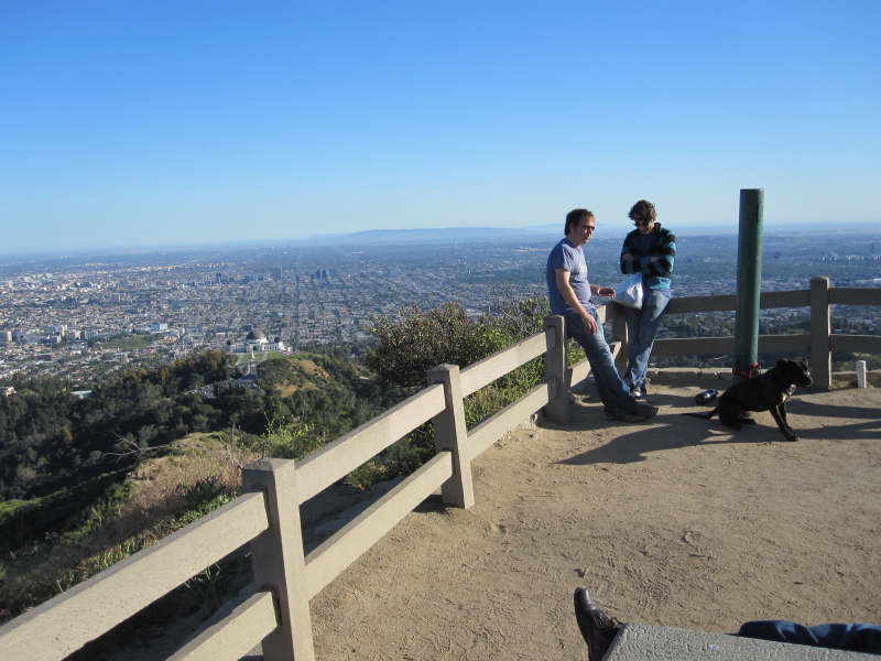
5:47 - Mt. Hollywood (1625'). Crown of park. About a dozen people here, which is not a lot considering the many millions who live close by. Breezy, cool. Snapping lost of pics. Low battery message on camera; turn off screen and use view finder (one of the several reasons why I searched hard to find a camera with a view finder!). Great visibility today. Everything is recovering well from the 2007 fire. The official survey marker puts the elevation at 1619'. The maps and literature put it at 1625'. Don't know why the difference, unless the whole mountain has grown over the years. Have a snack and look at maps. People coming and going. Windy. Love this place.
6:10 - Leave Mt. Hollywood. Wander over to northern edge to take pics of Mt. Chapel and Mt. Bell and surrounds. Walk the northern most of the two parallel routes. Pass the junction for the route to Captain's Roost cutting sharp left.
6:16 - Junction. Camera out of memory! I've used 2G! Going crazy with pics. Deleted 11 pics that I had already uploaded.
6:22 - Dante's View. Put on long-sleeve shirt. Walking in the shadow of Mt. Hollywood. Can see my return trial in Vermont Canyon below me.
|
|
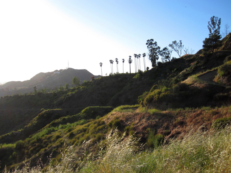
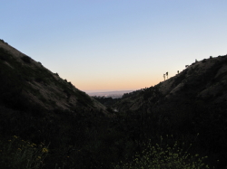
Looking west toward Mt. Lee (in distance) and Captain's Roost on the shoulder of Mt. Hollywood. View Large Image.
|
6:30 - Six-point junction south of Mt. Hollywood. Long shadows. Lot of foot traffic. Mess with camera; delete a video. Walk out on ridge jutting south for views. 6:42, back at junction and take the route bearing south to the west of this ridge. Trail narrows.
6:46 - Round ascending/descending ridge and cross a use trail. My route bends back north now descending into Vermont Canyon. In full shade of mountain now, but this route would be a grueling climb in full sun on a hot day. I like the narrow path; feels like hiking. Trial contours east then north.
6:55 - Hairpin turn cutting back south. A chain link fence runs along side the trail cutting off access to Bird Sanctuary. Final descent south alongside Bird Sanctuary.
6:58 - Vermont Canyon Road / Bird Sanctuary. Take pic; memory card full. The fence extends around and encircles the entire Bird Sanctuary. It is closed. Walk down the path along the east side for Vermont.
7:05 - Riverside Trail trailhead, near the top end of Greek Theater parking lot. My original thought was to follow the road back to the car, but hey, I'll take the trail to complete the loop. Trail starts climbing southeast then bends around heading north. I pass a path heading up the ridge. I figure this is the beginning of the route that climbs to Hogback Peak, the prominent summit along Hogback ridge (see blog post from February 17, 2012 describing a hike up that route).
|
|
Looking south at the top end of the trail coming up from Vermont Canyon Tennis Complex. View Large Image.
|
7:13 - Junction with trail coming up from tennis courts. Was here at 3:52. I decide to explore the path heading north. The map shows it dead-ending up canyon. The trail is narrow and informal, more of a use path. A rabbit scampers up the path. This is a peaceful time of day. I see trail users on Hogback above. The path gets more rustic as it goes along and ends at the foot of a granite slope on the east side of the canyon. There is the evidence of foot traffic continuing up that steep slope to Hogback. I entertain exploring up the slope some, but better judgment rules out (see blog post from October 6, 2011 describing a hike up that route). I delete a photo so I can take one last shot for today.
7:32 - Junction. I'm walking slow and soaking in the beauty of the peaceful place fading into night. See a deer bounding up the hillside. The voices of two loud-speaking women descending from the east breaks the tranquility. City lights below are twinkling. As I approach the tennis courts, I think about stray balls leaving the premises. So I look down and sure enough, I find three tennis balls in the brush. I toss them to a couple tennis players practicing up to the last light of day.
7:42 - Arrive at my car. Another thoroughly enjoyable hike in Griffith Park!
Epilog
This has certainly been one of my most enjoyable hikes in Griffith Park yet. Hard to imagine it getting better than this. Near perfect weather, great visibility, conquering my last remaining peak in the park, experiencing Hogback for the first time, lots of wild flowers, a feeling of solitude and escape even while sharing the trails with many others, and a good map (thanks Tom LaBonge) and good trail guide (thanks John McKinney). Can't wait to for another adventure hiking in Griffith Parking. How about next week?! 
 View Large Map / See also Griffith Park Maps page. View Large Map / See also Griffith Park Maps page.
(656 K)
 Glendale Peak Hike Description - Detailed trail guide including driving directions, recommended season, map, notes, links, and photos)
Related links on Dan's Hiking Pages:
-
Hiking Griffith Park - Overview and links to other hikes in Griffith Park
- Griffith Park Maps - A list of links to all the hike maps on this site as well as links to various other maps of Griffith Park
 My blog post for other hikes to Glendale Peak and Mt. Hollywood: My blog post for other hikes to Glendale Peak and Mt. Hollywood:
-
Griffith Park Six Peaks Hike - August 5, 2010 (Bee Rock, Mt. Chapel, Mt. Bell, Mt. Hollywood, Glendale Peak, Beacon Hill via Old Zoo Park)
-
Mt. Hollywood and Mt. Bell Hike - October 10, 2010 (via Griffith Observatory)
-
Mt. Lee and More in Griffith Park Hike - March 9, 2011 (Mt. Hollywood, Mt. Chapel, Mt. Lee, Cahuenga Peak via Griffith Observatory)
-
Mt. Bell and Mt. Hollywood in Griffith Park Hike - October 6, 2011 (via Commonwealth Canyon and Hodback Ridge)
-
Hogback, Glendale, Beacon in Griffith Park - February 17, 2012 (via Vermont Canyon)
-
Beacon, Glendale, Bee in Griffith Park - November 21, 2012 (ascend Beacon Hill via the north ridge trail)
NEXT > Brush Canyon to Mt. Bell and Bronson Caves - May 6, 2010
PREVIOUS > Bee Rock and Mt. Bell - April 16, 2010
|