| |

 |
| |
|
| |
 |
| |
 |
| |
 |
| |
 |
| |
 |
| |
 |
| |
 |
| |
 |
| |
 |
| |
Dan's Hiking Pages: Hikes in the San Gabriels and Beyond |
|
|
Mount Hillyer (6162')
Via Horse Flat (Chilao area)
Angeles National Forest / Southern California
|
Trail Stats
|
|
Mileage
|
4.6
|
|
Trailhead
|
5640'
|
|
Mt. Hillyer
|
6162'
|
|
Total gain/loss
|
702'
|
|
Gain/loss per mi.
|
305'
|
Hikes to Mt. Hillyer are well covered in the literature, for good reason: it's a pleasant area to hike and to experience some fine forest. John Robinson describes the area nicely:
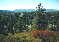
The Chilao-Horse Flats country is a gentle region of rounded ridgetops, shallow draws, and small flats set deep in the heart of the San Gabriels. The forest here is open and parklike; tall Jeffrey pines and incense cedars cluster in sheltered recesses and dot the rolling hillsides. The chaparral is rich and green and the sky a deep blue, with seldom a trace of the brown murkiness that so often invades the south slope of the range.
The broad, sprawling ridge crest of Mount Hillyer stretches northward over several bumps, curves around northeast in a crescent, and culminates with a 6,162-foot outcropping, which the USGS topo map marks as the summit. The hiking community, however, commonly recognizes the 6,200-foot-plus outcropping on the southern end of Hillyer�s ridgeline as the peak. Stately conifers obscure the views from the summit knobs, but if you stroll about Hillyer's spacious ridge, from various places you find splendid views in all directions—just not all at once.
As one who enjoys climbing peaks, I found pleasure not only in climbing Mount Hillyer, but also in achieving a vantage point in which to view surrounding summits summonsing me higher: Mount Pacifico (7124') looming to the north; Granite Mountain (6600'+) and Roundtop (6316') to the west; Waterman Mountain (8038') and Twin Peaks (7596"/7761') to the east. Even viewing the lower peaks silhouetted on the western horizon—Fox Peak, Condor Peak, Iron Mountain—stirred my desire to hike them. Due south, there's a view of Vetter Mountain, the site of the iconic fire lookout tower that was destroyed in the 2009 Station Fire. And further south stands historic Mount Wilson accompanied by its neighboring front-range peaks.
There are several routes and combinations of routes to climb Mount Hillyer ranging from 3 miles to 6 miles. The route described here is a pleasent 4-mile out-and-back hike via Horse Flats.
Season: All year
Even though this trail can be hiked all year long, keep in mind that it can get snow in the winter and can be uncomfortably hot in the summer during mid-day (there is not much shade en route). My favorite season is the spring when the temperatures are mild and the wildflowers are at their best. View Seasons of the San Gabriels for a detailed description of minding the seasons.
Getting to the Trailhead:
 From the Foothill Freeway (I-210) in La Canada, take Angeles Crest Highway (Hwy 2) north and east 27.5 miles to Three Points (2.2 miles past the junction to the Chilao Visitor Center).
The sign for the road says Santa Clara Division Camps, Sulphur Springs, and PCT parking. The closer sign says Bandido campground, and Horse Flats campground. Follow the road for 2.5 miles to the Horse Flats Campground turn-off . Turn left (south) and follow the loop road through the campground about 0.7 mile. The trailhead is on the left at south end of the campground as the road begins to loop back near campsite 10. There is a sign, "Silver Moccasin Trail, 11W03" pointing south to where the trail comes up from the Chilao campground. Another sign reads "Mt. Hillyer Trail / Mt. Hillyer 2 / Santa Clara Divide 3." Park here. A National Forest Adventure Pass is required to park. From the Foothill Freeway (I-210) in La Canada, take Angeles Crest Highway (Hwy 2) north and east 27.5 miles to Three Points (2.2 miles past the junction to the Chilao Visitor Center).
The sign for the road says Santa Clara Division Camps, Sulphur Springs, and PCT parking. The closer sign says Bandido campground, and Horse Flats campground. Follow the road for 2.5 miles to the Horse Flats Campground turn-off . Turn left (south) and follow the loop road through the campground about 0.7 mile. The trailhead is on the left at south end of the campground as the road begins to loop back near campsite 10. There is a sign, "Silver Moccasin Trail, 11W03" pointing south to where the trail comes up from the Chilao campground. Another sign reads "Mt. Hillyer Trail / Mt. Hillyer 2 / Santa Clara Divide 3." Park here. A National Forest Adventure Pass is required to park.
Trail Description:
 From the trailhead at the south end of Horse Flats campground, start from the sign designating "Mt. Hillyer Trail." After a minute the trail reaches an unmarked junction. Go left. Follow the trail as it winds southwest, west and northwest up the southeastern slope of Mt. Hillyer. You'll ascend through an open forest of Jeffery and Coulter pine, incense cedar, scrub oak, manzanita, and mountain mahogany. Huge granite boulders dot the landscape. From the trailhead at the south end of Horse Flats campground, start from the sign designating "Mt. Hillyer Trail." After a minute the trail reaches an unmarked junction. Go left. Follow the trail as it winds southwest, west and northwest up the southeastern slope of Mt. Hillyer. You'll ascend through an open forest of Jeffery and Coulter pine, incense cedar, scrub oak, manzanita, and mountain mahogany. Huge granite boulders dot the landscape.
 When you reach the summit ridge, climb to the 6,200-foot-plus outcropping to bag the high point. For a great view, walk southwest onto the firebreak several hundred feet for a splendid panorama of the rolling topography to the south and southeast, and the broad trench of Alder Creek dropping off to the west.
To experience all the offerings of Mount Hillyer, you can stroll 0.3 mile to the 6,162' point: Continue north on the firebreak along the main ridge past two high points (6200+') and follow the path as it curves eastward. After a little descent, you'll reach the point at which an old firebreak heads down the north slope to Santa Clara Divide Road (this is an altenate route for your return). You are treated with nice views to the north. Veer right and follow the ridge east and southeast over several knobs and outcroppings. Quite honestly, I couldn't tell which one is 6,162-foot point. So I climbed atop all the boulders along the ridge, enjoying varying views in different directions. Clearly this section of Mount Hillyer gets a lot less foot traffic than the 6,200-foot-plus high point, but it is indeed rewarding to explore.
Return the way you came. (See below for alternate routes.) 
Alternate Routes:
An optional route from Mt. Hillyer is to follow the trail down the north ridge to Santa Clara Divide Road. Then turn right (east) and walk the paved road 0.5 mile to the entrance to Horse Flat campground. Turn right and walk through the campground 0.7 miles to your car.
If you want to add another 2 miles to your trip, various hike guides describe the trip starting from the Chilao campground just west of the visitor's center, using a portion of the Silver Moccasin Trail (see
Hikespeak link below).
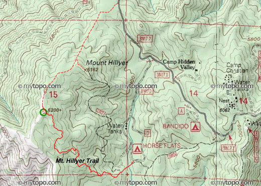
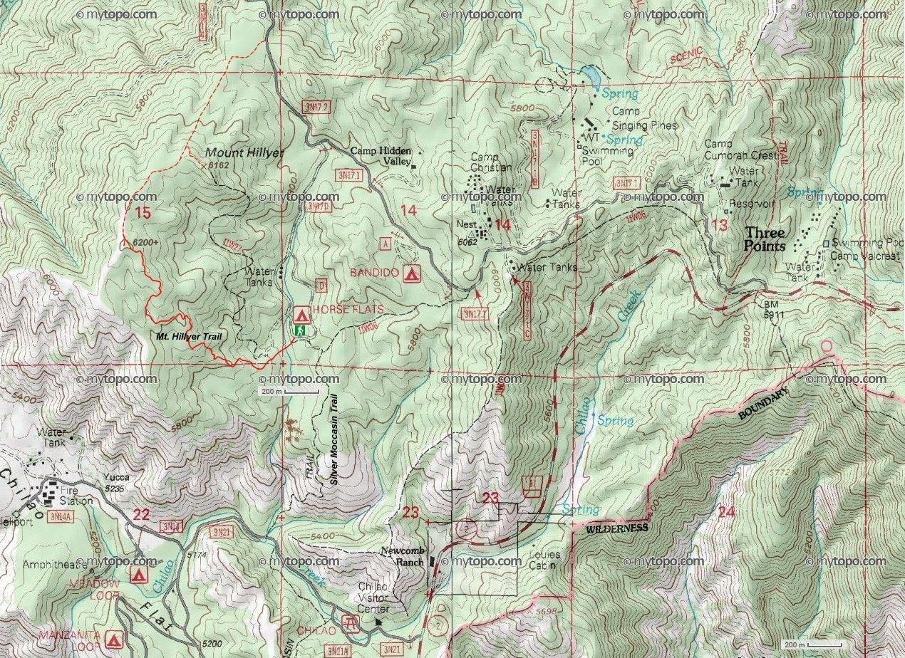
 View Large Topo Map (680K)
Trail Notes:
-
Permits: A National Forest Adventure Pass is required to park.
-
Topo map note: The USGS map topo (Chilao Flat Quadrangle, 1959 / minor revision 1994) does not show the trail. The trail (11W27) shown on the map from MyTopo.com as displayed on Peakbagger.com, on the Harrison map, and on the topo map posted at LocalHikes.com is NOT the Mt. Hillyer Trail described here or in the other trail guides. It is a different route.
-
Elevations: The trailhead at Horse Flats is 5640'. The highpoint of the Mt. Hillyer main ridge is 6200'+. A difference of 560'. My number of 702 is taken from Tom Chester's elevation analysis, which is based on the up and down of trail: 612 gain; 90' loss, then gain, thus a total gain of 702.
-
Mileage: The trailhead sign reads 2 miles to Mt. Hillyer. It is not clear if this is the mileage to the 6200'+ knob on the main ridge or for the 6162' summit indicated on the topo. I suspect the first since there is no formal trail to the second. The distance between the two summits is 0.3 mile. So don't be concerned whether you've hiked 4.0 or 4.6 miles. Just enjoy the mountain.
Hike Log
Mt. Hillyer via Horse Flats
8-9-03
|
|
4:30 PM
|
A: Trailhead (5640')
|
|
5:35/6:05
|
B: Boulders on main ridge (6200'+)
|
|
6:13/6:43
|
C: North End
Exploring the northeastern ridgeline and the 6162' summit.
|
|
6:51
|
B: Passing boulders on main ridge
|
|
6:53/7:07
|
Exploring southwest ridge
|
|
7:47 PM
|
A: Trailhead (5640')
|
-
Trail conditions: 8-9-03 - The trail follows a nice route, but much of the trail is deep ruts. No tread maintenance has been done in a long time. There were lots of bike tracks, which may be a significant contributor to the poor trail condition. In some places, bike riders rode up on the banks, eroding them. Someone has done some work in recent months in brush trimming—manzanita and mountain mahogany had been cut back from the trail. But the trimmings had been just left on the trail's edge (standard trail maintenance practice is to make an effort to move the trimmings to a less conspicuous location).
-
People traffic: 8-9-03, Saturday - There were no cars either at the Chilao trailhead or the Horse Flats campground trailhead. We encountered only one party of two hikers; they were coming down as we were going up. Total: 2 people in 1 party. I'm amazed that on a beautiful summer weekend, in fine hiking country such as Mt. Hillyer, we had the mountain virtually to myself. I was also surprised that Horse Flats campground was maybe a third to half full. Twenty million people in Los Angeles basin and still there are lots of nice campsites available in the local mountains.
-
Bugs: 8-9-03 - There were a lot of pesky gnats. Had no problems with mosquitoes until we arrived back at the trailhead at sunset. But we jumped into the car and avoided bites.
Trail Links:
- Hundred Peaks Section, Angeles Chapter, Sierra Club "Mt. Hillyer" - Brief driving directions and route descriptions. Nice historical background.
- Peakbagger.com - "Mount Hillyer." Geographic data, topo maps, trip reports, index to peak lists
- Hikespeak.com - "Mount Hillyer." by Seth Smigelski. Good hike description, photos, map. He presents a 6.25-mile round trip hike beginning at Chilao Visitor Center using the Silver Moccasin Trail to reach Horse Flats Campground.
- Hikes #57, 57-2 and 58 in the San Gabriel Mountains "Chilao to Horse Flats, Mt. Hillyer"
- by Tom Chester. Discussions of mileage and elevations. Links.
- Plant Guide to Mt. Hillyer Trail - by Tom Chester.
- LocalHikes.com - "Mt. Hillyer Trail - from Horse Flats" - by Allen Riedel. Bare-bones hike summery. As typical with many hikes posted at LocalHikes, this description is virtually useless to accurately guide the hiker on the route. The trail shown on his topo map is NOT the trail he describes nor is the one described here by me or in most other trail guides. The 3 miles distance he cites more closely reflects his topo map's trail, but the actual Mt. Hillyer Trail as indicated at the trailhead sign is 4 miles round trip.
Books:
- Trails of the Angeles: 100 Hikes in the San Gabriels - by John Robinson (Wilderness Press: Berkley). Hike 58: "Chilao to Horse Flats, Mt. Hillyer." Good trail descriptions with historical background. Gives alternate routes and trailheads, including Horse Flats.
- Afoot and Afield in Los Angeles County - by Jerry Schad (Wilderness Press: Berkley). Area A-7, Trip 4: "Mount Hillyer." Brief trail description from trailhead at Chilao. Gives alternate north route.
- Walking Southern California: A Day Hiker's Guide - by John McKinney (HarperCollinsWest: New York, 1994). Hike 51, "Silver Moccasin Trail." Good trail descriptions with historical background. Does not give directions to the 6162-foot summit point. Trailhead is Chilao.
Last Hiked: August 9, 2003
|
|