| |

 |
| |
|
| |
 |
| |
 |
| |
 |
| |
 |
| |
 |
| |
 |
| |
 |
| |
 |
| |
 |
| |
Dan's Hiking Pages: Hikes in the San Gabriels and Beyond |
|
|
Monrovia Peak (5409')
with Rankin Peak (5290') and Clamshell Peak (4360+')
via Rincon Red Box Road
Angeles National Forest / Southern California
 Hike Report: April 30, 2005 Hike Report: April 30, 2005
|
Trail Stats
|
|
Mileage (r.t.)
|
6.6
|
|
Trailhead
|
4854'
|
|
Monrovia Peak
|
5409'
|
Rankin Peak
|
5290'
|
Clamshell Peak
|
4360+'
|
|
Total loss/gain
|
1877'
|
|
Gain/loss per mi.
|
568'
|
For years traveling along the I-210 freeway to and from work, I have looked at 5,409-foot Monrovia Peak and wanted to climb it. The peak, along with its neighbor, Rankin Peak, stands tall and prominent over the front range of the San Gabriels. Unlike many of the summits in the San Gabriel Mountains, which can be accessed by a nice single-track trail with a 5- to 8-mile roundtrip hike, Monrovia Peak is not so ideal. To get there requires either one of several long hikes of 10 to 20 miles roundtrip up dirt roads and/or steep firebreaks, or getting a special permit and taking a long, bumpy drive in a in four-wheel vehicle.
So when a unique opportunity to bypass all of that arose, I jumped on it. In March, an online friend, Jeff McNabb, emailed me and mentioned he was hiking to Monrovia Peak with group from the Monrovia Canyon Park. I got particularly excited when he said that they would be driving to White Saddle, normally closed to the public. This cuts a 20-mile hike in half. Great, I'm in!
I arrived at the lower parking lot of the Monrovia Canyon Park at 7:30 on Saturday morning ready and raring to go. I met Jeff and signed in. I soon learned that the event was planned to give park volunteers an exposure to some of the natural surroundings of the park. There would be about 30 of us caravaning up the road. And I also learned that we would not be just driving to White Saddle, but all the way to Rincon Red Box Road to within a half mile of Monrovia Peak. What a pleasant surprise!
We stood around chatting as participants arrived. Finally, Kim, the leader, gathered us all together and went over the ride assignments. Ready, break.
I climbed into the back seat of Jeff's white Jeep with Jimi. Keith rode shotgun.
Mile 0.0 (8:25 AM) - The caravan of six vehicles starts the drive up through the park unto Sawpit Canyon Road. Our Jeep is fifth in line.
Mile 0.5 - Past the 160-foot Sawpit Dam. We continue driving northeast up scenic Sawpit Canyon.
Mile 1.1 - Gate for Boy Scout Camp Trask. Pavement ends.
Mile 1.3 (8:35) - Locked Gate - dubbed "Big Buertha"). As we drive, the two-way radio crackles as a gal in the lead vehicle points out items of interest -- Orange monkey flower, purple lupin, a young doe standing 50 feet from the road posing nicely for photos.
Mile 1.5 (est.) - The road turns south into Vassar Canyon briefly. Lots of greenery. Sparkling spring. Abundant poison oak throughout the drive.
Mile 1.8 (est) - Monrovia Police Department rifle range. It was built in the 1970's and is the reason the canyon is closed to the public on Tuesdays.
Mile 2.0 - Approaching Twin Springs. View of ridge dividing Sawpit from Sycamore Canyon.
 Mile 3.4 - Deer Park junction. The caravan stops to take advantage of the last toilet facility in route. Nice to unfold myself from the back of the Jeep and stretch my legs. A sign marks a trial that heads north for a short walk to Deer Park, the ruins of the one-time resort build by canyon pioneer Ben Overturff. We hung out for 10 or 12 minutes before continuing our drive.
The road begins a series of hairpin turns as it climbs high up the canyon wall. The scenery is striking. I ponder the feat of constructing this road. Bright yellow Spanish broom grace our route.
 Mile 4.8 - White Saddle (3220'). This gap marks the low point on the divide between Sawpit Canyon to the west and Cold Springs Canyon (which is the upper end of Fish Canyon) to the west. The caravan stops for a leg stretch. A sign marks the junction: Red Box Rincon Road 3.1 (pointing north); Fish Canyon Rd (pointing south toward Mount Bliss - 1N36); Monrovia Canyon Park 4.8 (pointing southwest toward where we drove up - 2N30).
I ponder the old Silver Fish Road (2N28), an abandoned fire road which starts at Highway 39 near Morris Dam in San Gabriel Canyon and wanders its way through Roberts Canyon, Fish Canyon, passed Stone Cabin Flat (2460), and ends at 1N36, .03 mile south of White Saddle. Kim mentions that a group of them had bushwhacked their way down the road all the way to Highway 39 three or four years ago. That's a long time in chaparral years. Today the route is not reasonably passable. See note and photos on the Summit 2843 page.
After a break of 10 or 12 minutes, we re-board our vehicles and get ready to go. Jimi decides to leave our Jeep to ride in another vehicle with more space. Our caravan continues on, now crossing over into the upper reaches of the Fish Canyon watershed.
Mile 5.3 - Cold Springs (water tank).
Miles 5 - 8 - Great views to the east down into Fish Canyon with Roberts and San Gabriel Canyons beyond. Big cone spruce begin to dot the scenery. These trees were a favorite choice for the lumber industry and were used in the construction of the San Gabriel Mission. They were cut and brought down into Sawpit Canyon to be hewn, hence the name.
Mile 8.0 - Locked gate. Just passed the gate is the junction for the Rincon Red Box Road, which connects Highway 39 in San Gabriel Canyon with Red Box junction near Mt. Wilson on the Angeles Crest Highway. The road is usually open to the public by permit from the Forest Service, although right now it is closed because of damage from the torrential rains of this past winter. As we cross over to the main ridge divide, we get glimpses between the trees into the West Fork San Gabriel River and beyond.
 Mile 9.2 - North side overlook. Views into the West Fork and across to the San Gabriel Wilderness and Devils Canyon. Now about 4,500 feet, it's really beginning to feel like we're up in the mountains - big trees, mature forest, cool breezes.
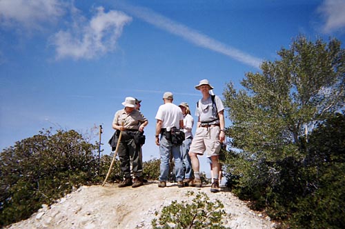
Mile 10.5 (10:05) - Trailhead to Monrovia Peak (4854') Our caravan parks in two clearings on the south side of the road. Feels great to unfold myself from the back of the Jeep. The big power transmissions lines cross directly overhead. The weather is pleasant. The group readies itself to head up the trail.
 10:15 - Hike begins. I was a little surprised that the beginning of the trail was not very clear. I'm not sure I would have easily found it following the directions posted on the Sierra Club 100 Peaks Section ("From the parking area, follow a use trail up the ravine through some brush to a firebreak."). The trail starts about a 100 feet to the east of the eastern most parking area, and parallels the road, heading back east. There was an adolescent fir tree whose branches blocked the trail, making the path almost invisible. We stepped over and ducked under the branches. There were several such trees within the first 50 yards or so.
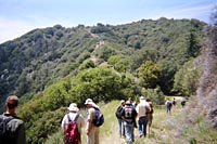
The trail curves south and follows a set of telephone lines up the slope. The path is not hard to follow and is reasonably free from brush, at least this early in the season. It's steep in places. The group starts to spread out.
10:44 - First summit, west of the main peak. Great views!
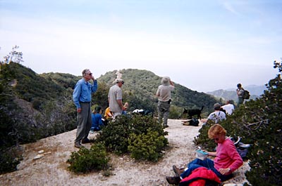
10:47 - Monrovia Peak (5409'). It took a while for the whole group to arrive. Great, unobscured 360 view. In the middle of the summit is a raised section with a peak register and survey maker. We took turns signing in.
I was a little disappointed that hazy weather obscured the views. Looking to the south, we could not see much more than 8 to 10 miles to the cities below. The haze muted the surrounding mountains.
To the west, Mt. Wilson and its neighborhood of peaks are clearly defined against the skyline.
This vantage point looking east toward Mt. Baldy is one of the best I've experienced in the San Gabriels. The whole ridgeline from Blue Ridge to Ontario Peak spans out with snow-covered summits. And the view east offers the unique opportunity to see Southern California's three tallest mountain groups: Mt. Baldy with distant Gorgonio Mountain and Mt. San Jacinto poking above the haze.
We lingered on the peak, snacking, chatting, and soaking in the vistas.
As we prepare to move on, the group made it's first split. Those who were doing just the Out-and-Back Hike to Monrovia Peak (1.4 miles r.t), would head back the way we came. The rest of us continue on.
11:40 - Leave Monrovia Peak. Hike south down the steep firebreak to a saddle then up another steep firebreak to what they call a false peak. Actually, there is nothing false about it. It's a very real and distinct summit. In fact, it's taller than Rankin Peak. It's just that it doesn't have a name. So let's call it Middle Peak and stopping accusing it of falsehood.
11:47 - Middle Peak (5360'+). Photo north toward Monrovia Peak, We continue down the southwest ridge to the saddle, than another steep climb to Rankin Peak.
 12:00 - Rankin Peak (5290'). This is the summit that is most pronounced from the valley floor and sometimes misidentified as Monrovia Peak. A small concrete and bronze monument commemorates Rev. Rankin, the peak's namesake. Photo looking northeast toward Monrovia Peak and Middle Peak. At this point, the second split is made. Those in our group who opted for the Two-Peak "Stairmaster Special" (2.6 miles r.t., 1,000 feet elevation gain) turn around and head back the way we came.
12:15 (est.) - The rest of us left Rankin Peak and start down the steep firebreak on the southwest slope. I ponder what shire gruel it must be hiking up this route on a hot, sunny day.
 12:22 - Place on the ridge where a path drops sharply down the west slope. Some of our party went down it while another went straight down the ridge. We consulted maps and the GPS and talked on a radio to those down below and determined that the desired route was to continue down the ridge. So down we continue. In a couple minutes the route cuts sharply to the right (northwest) and travels laterally across the slope. Purple lupin blossoms abound along the path (View large photo).
12:33 - Upper Clamshell Truck Trail - Ridge divide between the northern and southern watersheds. Here is where the group slits again. Those opting for the Two Peaks and Return via Spring Camp (3.8 miles r.t. 1,046' gain), head north on the road back to the cars. The rest of us continue on.
12:40 - Leave our split point. The truck trail continues west, crossing over to the north side of the ridge divide and through a woodsy forest. A deer hops down the road in front of us. It feels great to actually be hiking on a decent road with a gentle grade for the first time on this hike.
12:58 - Road now crosses over the ridge divide to the south side. Views open up to City of Monrovia and the valley beyond, although still shrouded by haze.
1:07 - Photo south into Monrovia Canyon. Dubbed as a good dam view. Haze still obscures the view of the valley.
|
|
Looking west from Clamshell Truck Trail toward the firebreak route leading to Clamshell Peak.
Large photo
|
1:15 - Ridge Junction. The route now leaves the road and steeply climbs the firebreak up the east ridge of Clamshell Peak. More huff and puff.
1:23 - Clamshell Saddle (the wide, gentle low spot between the north and south summits of Clamshell Peak. We head north.
1:27 - Clamshell Peak (north summit, 4360+). We sign the peak register. Photo northwest toward Newcomb Pass, group lingering around. Nice views west down into Santa Anita Canyon and Chantry Flat. Can see a washed out section of the road. Photo east toward Rankin Peak.
1:47 - Leave Clamshell Peak north summit.
1:50 - Clamshell Peak (south summit). Good views south toward Arcadia and Monrovia. I keep pondering how great this hike would be with clear visibility. The sun is warm. This is where the group splits for the last time. Those opting for the Three Peaks and Return via Spring Camp (6.6 miles r.t. 1,877' gain) head back the way we came. That group is just Jeff, Keith, and me. The remainder of the group will head down the south ridge all the way to bottom of the mountain (7.0 miles total trip, cum. gain 1,125', cum. loss 4,694'). Kim traps a horned toad and we all gather around as Jimi gets some micro close-up shots.
1:58 - Leave Clamshell Peak south summit.
2:07 - Road. The uphill grade is not bad, but the sun is warm and the air feels humid. It's nice to be down to a threesome.
2:21 - Ridge divide, crossing back over to the north slope. I appreciate the pleasant shade much more now than on our first pass along this route.
2:36 - Ridge divide (the location where we had first joined the Upper Clamshell Truck Trail at 12:33). Now we continue on the road, new territory for us for this hike. Road descends.
3:09 - Locked gate. Fork in road heading back (maybe down to Spring Camp), not shown on the topo map. A broken off sign indicates 2N31A (probably referring to the side fork). Now the road ascends. Power lines overhead as are the telephone lines.
3:15 / 3:17 - Locked gate - junction with Rincon Red Box Road. Gate indicates 2N31 (referring to the route from which we just came). Explore briefly a side spur leading to south to a clearing.
3:22 - Back to the Jeep. What a nice hike!. We load up and begin our long drive back. Keith let me sit shotgun on the return trip.
4:32 - Arrive back at the Monrovia Canyon Park lower parking lot. The group had not yet arrived from coming down the ridge.
Epilog - What a pleasant outing! Beautiful high country. Sweeping views. Nice temperatures. Lots of green from the record rains. Three peaks. This is certainly an area to which I'd like to return. And good company. Kudos to these folks who spend themselves volunteering at Monrovia Canyon Park. What a great group! It was a pleasure spending the day with them. 
Other Trail Notes:
- Bugs - 4-30-05. Lots of little fly bugs, really irrating. They have a nasty bite. I was wearing a good dosage of deet, but others were eaten alive. I got only two bites.
- High Points - At 5,409 feet, Monrovia Peak is certainly not a high mountain by California standards. Actually, there are at least 42 peaks in the San Gabriel Mountains that are higher. Monrovia Peak, however, is higher than the highest points of 30 states! See United States State High Points from peakbagger.com.
Related links on Dan's Hiking Pages:
Trail Links:
- Hundred Peaks Section, Angeles Chapter, Sierra Club "Monrovia Peak" - Gives four routes to Monrovia Peak, summarized below:
Route 1 - From Monrovia Canyon Park up Bill Cull Trail up the south ridge - 10 miles r.t. 5300' gain. [Route withdrawn due to trail closure]
Route 2 - From Monrovia up Clamshell Truck Trail over Clamshell and Rankin Peaks - 12 miles round r.t., 5300' gain.
Route 3 - From Monrovia Canyon Park up Sawpit Canyon to White Saddle to Rincon Red Box Road to the Monrovia Peak trailhead up the north ridge to the summit - 20 mile r.t., 4500' gain. Note: This is the route we drove. Correction: The real distance is actually 22.4 miles r.t. not 20 (10.5 miles on the road, and 0.7 mile on the trail, one way). They had previously put the distance at 14 miles r.t. but changed it to 20 miles (maybe when they updated the page on 6-14-05).
Route 4 - Drive the Rincon Red Box Road to the trailhead. Hike the north ridge to the summit - 1 mile r.t., 600' gain. (Our calculation showed it at 1.4 miles r.t.)
Route 5 - From Mt. Wilson via Newcomb Pass - 21 miles r.t., 3700' gain (1700' out plus 2000' on return).
- Hike D10. Monrovia Canyon - by Christopher Brennen, Adventure Hikes and Canyoneering in the San Gabriels. Good description of an adventure hike coming down canyon, dropping in from Upper Clamshell Road. Topo map and two photos.
- Guide to hike #48-2 Duarte to Monrovia Peak via Van Tassel Fire Road - Detailed hike log by Tom Chester.
- Monrovia Canyon Park official website - by the City of Monrovia. It USED to have lots of information, map, photos, history, helpful tips, etc. But they gutted the site and now the information is bare bones.
Last Hiked: April 30, 2005
|
|