| |

 |
| |
|
| |
 |
| |
 |
| |
 |
| |
 |
| |
 |
| |
 |
| |
 |
| |
 |
| |
 |
| |
Dan's Hiking Pages: Hikes in the San Gabriels and Beyond |
|
|
 San Antonio Falls
Angeles National Forest / Southern California
|
Trail Stats
|
|
Mileage (r.t.)
|
1.2
|
|
Trailhead
|
6160'
|
|
Falls
|
6400'
|
|
El. gain
|
250'
|
|
Gain per mi.
|
416'
|
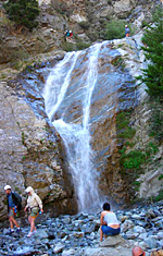
At about 100 feet tall, San Antonio Falls is one of the most impressive waterfalls in the San Gabriels. In the spring when the snow is melting quickly, the water tumbling over the three tiers offers a delightful show. And San Antonio Falls are easy to get to. A leisurely stroll of slightly over a half mile on a paved road brings you to the overlook. Then a little scramble of about three minutes down a narrow dirt path gets you to the base of the falls.
If you are a diehard hiker, most likely your visit to the falls is simply in passing as you are on your way to more lofty destinations, such as Mt. Baldy (officially Mt. San Antonio), the crowning glory of the San Gabriels. On a typical fair-weather day, this waterfall gets lots of guests, including families, small children, romantic couples, ladies in dresses, grandparents, tourists, canyoneers, dogs. On a warm day after a long hike, the falls can be quite refreshing.
Season: April - July
Because the drainage area above the falls is relatively small, the falls are only showy after a big rainstorm or during the rapid snow melt season, somewhere from about March through July. After the snow has melted, springs in the upper canyon keep waters flowing down, but at a subdude level.
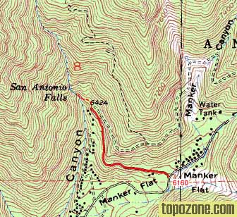
Getting to the Trailhead:

|
7-2-06 - San Antonio Falls. The little figures you see on the top of the first tier are trained canyoneers repelling down the falls. Don't attempt climbing around the falls without expert training and equipment.
View large image
|
From the new 210 Freeway extension, driving east: Exit Baseline Road in Claremont. Turn left on Baseline. In one block turn right unto Padua Avenue. In 1.7 miles turn right onto Mt. Baldy Road (stop sign). After 7.2 miles you pass the Angles National Forest Mt. Baldy Visitor Center in Mt. Baldy Village. You can get a Forest Adventure Pass here. Continue a few miles up to Maker Flats.
From the new 210 Freeway extension, driving west: In Upland, exit Mountain Ave./Mt. Baldy Exit, Exit 54. Turn right and proceed north on Mountain Ave. Drive 5 miles to Mt. Baldy Road. Turn right (north) and after 5 miles you pass the Angles National Forest Mt. Baldy Visitor Center in Mt. Baldy Village. You can get a Forest Adventure Pass here. Continue a few miles up to Manker Flats.
Park at upper end of Manker Flats Campground in one of the dirt areas near the gated Falls Road on the left (if you reach the ski lift parking lot, you've gone a quater mile too far). Your hike will proceed up this road. A National Forest Adventure Pass is required for parking.
Trail Description:
 From the upper end of the Manker Flats campground, notice Falls Road on the north side of the street. There are a couple of porti-potties there. Start walking up the paved road past the locked vehicle gate. You'll pass through an open conifer forest. As the road bends north you begin to have excellent views up San Antonio Canyon toward Baldy Bowl. If you have sharp eyes you may be able to spot the green Sierra Club Ski Hut as a tiny dot perched 2,000 feet above.
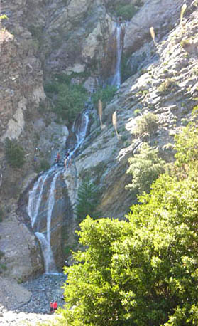
After 0.6 you reach a hairpin turn where the falls come strikingly into view. To hike to the base of the falls, descend the dirt path, but be careful, it's somewhat precarious in places.
At the base of the falls, only the bottom tier is seen, but it's quite a display. The lower cascade tumbles 40 feet unto a streambed of broken rock.
After an enjoyable visit to the falls, return the way you came.

Trail Notes:
-
Parking - A National Forest Adventure Pass is required.
-
7-22-07 - The falls were flowing, but meagerly. This has been the driest year on record. View photo. 8-21-11 - The falls were flowing pretty well.
Related links on Dan's Hiking Pages:
Links:
Books:
- Afoot and Afield in Los Angeles County - by Jerry Schad (Wilderness Press: Berkley). Area A-12, Trip 6: "San Antonio Falls." Good trail description with brief background.
- Trails of the Angeles: 100 Hikes in the San Gabriels - by John Robinson (Wilderness Press: Berkley). Hike 93, "Manker Flat to Upper San Antonio Creek, Baldy Bowl, Mt. San Antonio Summit" (added to the 7th Edition, April 1998). Mentions the falls in his trail description to Baldy's summit.
Last Hiked: July 22, 2007 (to base of falls) / August 21, 2011 (past on Falls Road)
|
|