Sunset Peak (5796’)
via Glendora Ridge Road
Angeles National Forest / Southern California
|
Trail Stats
|
|
Mileage (r.t.)
|
7.8
|
|
Trailhead
|
4340'
|
|
Summit
|
5796'
|
|
El. gain
|
1456'
|
|
Gain per mi.
|
373'
|
At nearly 6,000 feet, Sunset Peak provides a splendid perch and 360-degree view of the surrounding San Gabriels and the vast human sprawl to the south. It’s easy to see why the Forest Service selected this location for a fire lookout tower, which stood here from 1927 to the 1970s.
This hike has its greatest reward in the winter when snow blankets the towering northern panorama capped by 10,000-foot Mt. Baldy. The downside to this hike is that the conventional routes are on fire roads, and sometimes they are shared with bicycles and motor vehicles. Fire roads are not my favorite, but I find Sunset Peak to be a worthy enough destination to overlook hiking on wide, dirt lanes. And if you like a challenge, you can bypass the fire roads and climb the peak via steep use paths (see alternate routes below).
Season: November through June
This trail can actually be hiked all year long, but keep in mind that it can get snow in the winter and can be uncomfortably hot in the summer. There is little shade en route except from shadows cast by the surrounding terrain when the sun is low in the sky. My favorite season is winter when snow blankets the northern panorama. In spring everything is green and the wildflowers are at their best. View Seasons of the San Gabriels for a detailed description of minding the seasons.
Getting to the Trailhead:

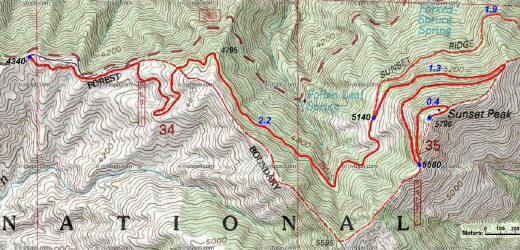
 From the 210 Freeway extension, driving east: Exit Baseline Road in Claremont. Turn left on Baseline. In one block turn right unto Padua Avenue. In 1.7 miles turn right onto Mt. Baldy Road (stop sign). Drive 7.1 miles to Glendora Ridge Road in Mt. Baldy Village. Turn left on Glendora Ridge Road, drive up to Cow Canyon Saddle (0.9 mile), and continue west to Forest Service Road 2N07 on the left (4.2 miles from Mt. Baldy Road). Park in the large dirt clearing.
From the 210 Freeway extension, driving west: In Upland, exit Mountain Ave./Mt. Baldy Exit, Exit 54. Turn right and proceed north on Mountain Ave. Drive 5 miles to Mt. Baldy Road. Turn right and drive 4.7 miles to Glendora Ridge Road in Mt. Baldy Village. Turn left on Glendora Ridge Road, drive up to Cow Canyon Saddle (0.9 mile), and continue west to Forest Service Road 2N07 on the left (4.2 miles from Mt. Baldy Road). Park in the large dirt clearing.
 Map to trailhead:
Glendora Ridge Road and 2N07
Map to trailhead:
Glendora Ridge Road and 2N07
No Adventure Pass Needed - Previously a National Forest Adventure Pass was required for parking at this trailhead since it is within the Angeles National Forest. As of September 2016, the Recreation Enhancement Act restricts the requirement for an Adventure Pass to only sites that provide designated amenities. See here for more Adventure Pass information.
Trail Description:
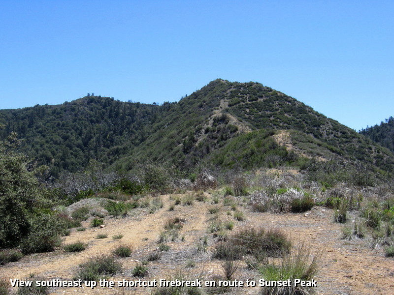
 From the trailhead, walk around the locked vehicle gate and head east on the wide dirt road (2N07) which parallels the highway at first. In a few minutes the road bends right (south) for the first leg of a long switchback (which can be short-cut by climbing the fire break - see Alternate Routes below).
 Just short of a mile the road reaches a hip and cuts sharply southwestwardly and contours in and out of a canyon. Stately pines begin to mark the transition from the brushy chaparral to higher elevation plant communities. As you head north across the west flank of Sunset Peak, you reach a Y junction (5140’) at 2.2 miles. The old dirt road on the left comes up from Cow Canyon Saddle (1.9 miles) but that route is no longer featured in the literature because it cuts through private property (see Alternate Routes below: Old Route from Cow Canyon Saddle). Veer right. The road soon bends east and traverses the north flank of the peak. At 3.1 miles you reach the hip on the northeast ridge of Sunset Peak. There is a climber’s route that follows this ridge from Cow Canyon Saddle all the way to the summit which is a possible alternate route for peak baggers with billy-goat tendencies (see Alternate Routes below: Northeast Approach). From this hip you are treated to superb views down into San Antonio Canyon, up to Ontario Ridge, and out toward the human sprawl beyond. The road cuts sharply southwest and doubles back across the north flank.
Soon you bend south and at 3.5 miles you arrive at the upper ridge junction (5580’). The wide dirt road (Sunset Ridge Fire Road) continues south (straight) to Culver Peak and eventually ends about 12 miles near the mouth of San Dimas Canyon. Make a U-turn (north) and notice another Y-junction. The steep path scaling the ridge on the right is a shortcut to the summit. For the main route, veer left and follow the road north as it winds around the peak 0.4 mile to make its final ascent from the northeast.
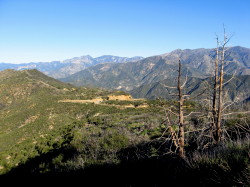
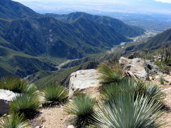
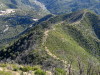
From the broad, barren summit of Sunset Peak (5796’) you are rewarded with a stunning 360-degree panorama.
|
|
Looking southeast from Sunset Peak toward the mouth of San Antonio Canyon. View Large Image
|
Concrete footings and other debris are reminders of the fire lookout tower which stood watch at this location for more than 40 years. Dedicated fire spotters with eyes peeled would scan the surrounding mountains looking for wildfires. If you look north 2.25 miles you can see Lookout Mountain (6812’), which got its name from the fire lookout tower which was built in 1915 as the first fire lookout in the Angeles National Forest. When it was severely damaged by weather in 1927, fire spotting duties shifted over to Sunset Peak. You also have direct line-of-sight northwest 9.5 miles to South Mount Hawkins (7783’) where a fire lookout tower stood from 1937 to 2002. And looking southwest 7.25 miles you can see Johnstone Peak (3178’), which hosted a fire lookout tower from 1934 to 1992. You can visualize the interaction between the fire spotters manning these three towers to protect our wonderful mountains.
If you are a peak bagger, how many named highpoints in the surrounding San Gabriels can you spot from this summit? There are at least 40 visible from here.
Return the way you came or consider the alternate routes below. 
Alternate Routes:
There are several possibilities for using use paths to avoid the fire roads and to add more challenge to your outing. But please be aware that informal use paths can be brushy, have loose footing, and can be quite steep.
 Northeast Approach: This route climbs a use path straight up the ridge from Cow Canyon Saddle (4523’) to Sunset Peak for 3.0 miles round trip and 1,275 feet in elevation gain (850 feet gain per mile). Park your car at Cow Canyon Saddle, walk across the street, and find the path that heads southwest up the ridge. You’ll climb straight up to the summit. You’ll cross the main trail at one point, in which you can opt to follow that route 1.1 miles to the summit.
West Approach: Starting from the trailhead for N207 at Glendora Ridge Road, you can avoid most of the walk along the fire road by using a firebreak that takes you all the way to the upper ridge. From the trailhead, walk around the locked vehicle gate and head east on the wide dirt road (2N07) which parallels the highway at first. At about 0.2 mile the road bends right (south), but for the shortcut, continue straight (east) up the firebreak 0.16 mile to meet 2N07 again. Turn left and in about 30 feet on the right, find the narrow path that leaves the road and mounts the ridge. This is your route. A use path follows the firebreak southeast up the ridge gaining 875 feet in about 1 mile culminating at a knob (5595’). Turn left (northeast) and descend along the ridge about 0.3 mile to Sunset Ridge Fire Road. Continue northeast on the road 0.13 mile to the ridge junction (5580’). To the left is the main route (2N07) coming up from Glendora Ridge Road. In front of you is a Y-junction. The steep path scaling the ridge on the right is a shortcut steeply climbing 215 vertical feet in 0.15 mile to the summit of Sunset Peak. Or you can veer left and follow the fire road 0.4 mile as it heads north and winds around the peak to make its final ascent from the northeast.
Of course you have various options. You can ascend via the shortcut and then use the main route for your return, or you can use the main route for your ascent and then use the shortcut for you return (as I did on my hike on April 13, 2008. Or you can piece together any number options using the portions of the main route and shortcuts coming and/or going.
Old Route from Cow Canyon Saddle: A fire road begins at Cow Canyon Saddle and heads 1.9 miles southwest to intersect 2N07 coming from the west. This route provided a 7.2-mile-round-trip hike to Sunset Peak as previously promoted in the literature. But since a portion of the route crosses private property, authors have switched to the longer route from the west. The Sierra Club Angeles Chapter Hundred Peaks Section makes the following statement on its Sunset Peak climbing guide: “This route passes a locked and posted gate. If ownership has not changed, this card gives you permission to walk on the road.”
 View Large Map (604 K)
Hike Log
Sunset Peak
4-13-08
|
|
8:00 am
|
A: Trailhead (4340')
|
|
9:02
|
B: Jct to Cow Cyn (4140')
|
|
9:38
|
C: Ridge jct (5580')
|
|
10:04/11:00
|
D: Sunset Peak (5796')
Return via south ridge
|
|
11:10
|
C: Ridge jct (5580') - Descend south via ridge fire break
|
|
12:25
|
Back to road - Continue to descend via fire break
|
|
12:50 pm
|
A: Trailhead (4340')
|
|
|
|

|
Trail Notes:
-
Mileage and elevation - I’ve based the mileage on satellite technology, which corresponds to the Harrison map except for the distance from the trailhead to the 5,140 junction. Harrison puts it at 2.5 miles; it should be 2.2, thus a total 7.8 miles round trip. Robinson, McKinney, and HPS all put it at 7 miles round trip, which is 0.8 short. My elevation gain of 1,456 is simply calculated by subtracting the trailhead (4,340’) from the summit (5,796). Robinson, McKinney, and HPS have it ranging from 1,200 to 1,350, which might be a hold-over from when the hike was originating from Cow Canyon Saddle (4,523’).
-
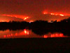 Wildfires - Much of the area was burned by the Williams Fire 2002, which began on September 22, 2002 and consumed 37,240 acres. Vegetation is rebounding well but evidence of the fire still abounds. The Williams Fire merged with the Curve Fire, which began on September 1, 2002 and consumed 20,857 acres and destroyed the historic South Mount Hawkins fire lookout tower.
-
Highpoint - Sunset Peak is certainly not a high mountain by California standards, but it is higher than the highest points of 32 states (see United States State High Points from peakbagger.com).
Related links on Dan's Hiking Pages and Blog:
-
 Photo Album: Sunset Peak Hike - April 13, 2008 - 78 photos with captions [Album is currently unavailable waiting a new home after the demise of Google+]
-
 Fire Lookouts Fire Lookouts
Links:
- Hundred Peaks Section, Angeles Chapter, Sierra Club - Peak 15F "Sunset Peak." Driving directions and bare-bones guide for two hikes: Route 1: The northeast shortcut from Cow Canyon Saddle; Route 2: The hike via 2N07 from Glendora Ridge Road (both hikes described above).
- Peakbagger.com - "Sunset Peak." Geographic data, topo maps, trip reports, index to peak lists
Books:
- Trails of the Angeles: 100 Hikes in the San Gabriels - by John Robinson with Doug Christianson (Wilderness Press, 8th Edition). Hike 90: "Glendora Ridge Road to Sunset Peak." Provides a brief overview and short trail description. It’s lean on details and with some inaccurate mileage and elevation gain. He puts the distance at 7 miles round trip with 1,350 in elevation gain. In his Sixth Edition he describes the route from Cow Canyon Saddle and puts it at 5 miles round trip (but it’s actually 7.2 miles round trip. Oops). I first hiked to Sunset Peak following this description with my son on Thanksgiving 2000.
- Los Angeles County: A Day Hiker's Guide - by John McKinney (The Trailmaster, 2006). "Sunset Peak." Provides a brief overview and short trail description. It’s lean on details and with some inaccurate mileage and elevation gain. He puts the distance at 7 miles round trip with 1,200 in elevation gain.
- Afoot and Afield in Los Angeles County - by Jerry Schad (Wilderness Press: Berkley). Area A-12, Trip 3: "Sunset Ridge." Presents a one-way trip from Cow Canyon Saddle 12.7 miles to Marshall Canyon County Park, climbing over sunset Peak en route. Puts the mileage to the summit at 2.9 miles.
Last Hiked: April 13, 2008
|