|
Trail Stats
|
|
Mileage (r.t.)
|
11.2
|
|
Trailhead
|
840'
|
|
Mt. Bliss
|
3720'
|
|
White Saddle
|
3220'
|
|
El. gain
|
3380'
|
|
Gain per mi.
|
603'
|
As it became Memorial day weekend, I found myself wanting to take a hike. I had a lot of household things to handle, so I made no plans. Plus the weather has dominated by a marine layer—the foggy "June Gloom."
By the time it approached Monday, I had a productive weekend so was thinking I should reward myself with a hike. So on Sunday night when I went to bed I thought that if I naturally woke up in time to be on the trail before sunrise, then I'd take a hike. I awoke at 4:30 a.m., so hiking it was. As I got ready I really didn't know where I was going to hike, but I figured it should be someplace close so I could be home by noon. I choose Mt. Bliss with the trailhead just minutes from my house.
5:45 - Start hike. The weather is cool and gloomy with heavy fog. Since I'd hiked Van Tassel fire road numerous times and had a posted hike write-up, I don't have to occupy my mind with thinking through a hike description. So from the outset, I decide to log blooming plants. Mustard, golden yarrow, elderberry... (see list below). I have an enjoyable time. And even though we had a record dry season, the chaparral is green with lots of blooming plants.
6:27 - Power line retaining wall. Still overcast and gloomy, but feels good. Note 19 blooming plants by this point.
6:52 - Sun beginning to cut through the marine layer.
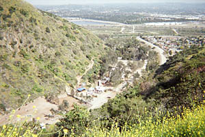
7:19 - Spanish Canyon View. Now I am above the clouds in full sun. The sky is blue and a fluffy layer of cotton balls blankets the valley and canyons below. I enjoy the warm sun and dry air—gives me a chance to dry out. It's interesting that I can work up such a sweat on a cool, foggy day. But I guess it's the high humidity that creates the soaking.
7:37 - Stop to enjoy the wonderful fragrance of Spanish broom radiant in the morning sun. A couple minutes later I step aside to smell another Spanish bloom plant, this one still in the shade, and there was hardly any fragrance. I was captured by the thought, "The warmth of the sun releases the fragrance." I began to ponder its spiritual implications. One aspect is the sun as light and I reflected on the Scriptures that declare that Jesus Christ is the light of the world and we are called to live in the light (John 8:12; 1 John 1:5-7). And God spreads through us the fragrance of the knowledge of Christ (2 Corinthians 2:14-16).
8:06 - Reach the summit of Mt. Bliss (3720'). It's quite and peaceful. And with the marine layer blanketing the urban sprawl, there is a feel of remoteness. Looking in the coffee that can that hosts the summit log, I notice a new logbook was placed there the day before. I thumb through the old logbook and note the four other times I've been to this summit since April 27, 2003. I turn on my BlackBerry to see if I have reception; none. I linger in this special place for almost an hour.
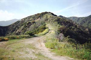
8:55 - Leave the summit. I decide to head north down the ridge to see if there is a doable alternate route. There's a decent use path that dips down to a saddle, climbs another welt on the ridge, and then descends to another saddle. Here there is a steep, old firebreak that descends north directly to the road.
9:07 - Start decent. After a couple minutes the firebreak ends at a junction, marked by water hydrant SW11. An unmaintained road heads right (east). The main road to the left (southward) is marked with a sign, 1N36. I veer right on the road and descend north toward White Saddle.
9:28 - Junction. 1N29 cuts back sharply toward the southeast. (It heads down to Stone Cabin Flat.) I continue on.
9:35 - White Saddle (3220'). I've been here before, but never from the route I just came. Three middle-aged men on mountain bikes are leaving the saddle heading down toward Monrovia. The sign reads, Red Box Rincon Road 3.1 (pointing north); Fish Canyon Rd 6 (pointing south); Monrovia Canyon Park 4.8 (pointing west).
9:45 - Leave White Saddle climbing back south. Getting warm.
10:12 - Junction where the firebreak intersects (Hydrant SW11). Now I'm on a section of road I've not traveled. As I pass the draw which leads up to the ridge to the south of Mt. Bliss, I note that it is particularly overgrown. I had climbed that route on my first trip to Mt. Bliss four years earlier, but now it looks impassable.
10:20 - Junction to Bliss. Now I'm back on the route I had come up on.
10:42 - Spanish Canyon view. Passing SW14 at 11:05 I see a deer.
11:16 - Power Line retaining wall. The hike back seems long. Sun is warm. I walk at a mild pace.
12:04 - Finish hike.
Epilog - Pleasant outing. It was good to have extended the hike to visit White Saddle. Not only did it lengthen my exercise by 2.6 miles, making the total hike 11.2 miles r.t. (3380 el. gain), it also afforded me a link of the road where I've never been. I also enjoyed my blooming plant survey. Of the 35 flowering plants, I could identify all but 3 or 4. It gave me some satisfaction in that it was but only a few years ago that I could hardly recognize anything in the incredibly species-rich chaparral. 

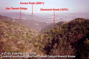 My first trip to Mt. Bliss - Mt. Bliss stands as a prominent summit in clear view from my home in Azusa. For years it called to me. And so on Sunday, April 27, 2003, I finally assaulted it. Actually, the hike was only to be a stroll up the fire road for bit, beginning at 3:30 in the afternoon. But something drew me higher and higher. I had set my turn-around time at 5:30, but when I reached the ridge of Spanish Canyon at 5:12, and views of the summit opened up, I got inspired to press ahead. And I'm glad I did.