 Beacon Hill
Griffith Park / Los Angeles / Southern California
 Hike Report: April 8, 2010 Hike Report: April 8, 2010  Beacon Hill Hike Description Beacon Hill Hike Description
I love hiking in the springtime. And since I have been working in L.A., Griffith Park has become my favorite after-work hiking venue during the long-daylight season. A crack-of-dawn meeting at work afforded me the occasion to get off early and hit the trail. I've not hiked the east end of the park, so I was excited about exploring some new ground and bagging Beacon Hill.
My primary hiking guides for Griffith Park has been Jerry Schad's Afoot and Afloat in Los Angeles County, and John McKinney's Los Angeles County: A Day Hiker's Guide. I have studied all their hike descriptions and maps and have been trekking my way through the park as time avails. As I was preparing for this hike, I grabbed Day Hikes Around Los Angeles by Robert Stone. It had been sitting on my shelf but I had not yet used any of his write-ups for a hike. Beacon Hill seemed it would be a good hike, so armed with Stone's map and trail description I headed off to Griffith Park. [Thankfully, in his 2012 edition, he has corrected the problems that I cite in my narrative below. See Book Note.]
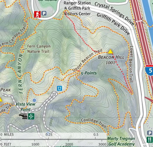
3:29 p.m. - Leave my office in Echo Park driving north on Sunset Blvd. Meander my way to Los Feliz Blvd. Lot of traffic, typical on that street this time of day. Turn left on Crystal Springs but shortly run into construction. Not sure of the route now but press through to get to the merry-go-round parking lot as Stone describes.
I'm a little confused by his directions and map. The trail directly across the road seems to be the return route, so I walk up the paved road about 40 yards and find a trail on the left. There are no signs, but it seems to be the correct route up Fern Canyon. I linger a bit still uncertain.
4:10 - Commit to heading up that trail. The beauty of the surrounds grab me. Almost immediately there is a junction on the left which I figure to be the Fern Canyon Nature Trail. No signs and the trail looks in disuse. Probably burned out with the May 2007 fire and not rebuilt. My trail begins to narrow high grass hugging close, which is a little puzzling to me, knowing the freeway-width "trails" typical of this park.
4:14 - Fern Canyon Amphitheater. Ooops, I am on the wrong trail. I hate false starts. (Note to self: write a better trail guide.) I surmise that the main trial is not to far above me and wonder if there is a reasonable route to it. I climb the steps to the top of the amphitheater and discover the main trail!
|
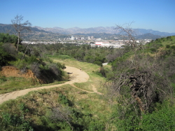
|
Looking northeast from Fern Canyon Trail toward Glendale.
|
4:19 - Start my way up Fern Canyon Trail. The views behind me are opening up nicely to the cities beyond. The hills are green and I can see my route winding its way up the canyon before me. I contour along the west slopes of Fern Canyon. The warm sun feels good. Dead trees stand as a stark reminder of the horrible fire of May 2007. The chaparral is recovering nicely.
4:23 - Round a hairpin turn near the head of the canyon crossing its water course. Now heading north on the east canyon wall. Round an outward bend with spended views. A use path heads down the ridge; maybe an alternate route to consider for another time. As I bend back south I take note of a water tank up near the ridge. There is a strange beauty to oak trees that have been burned and are now shooting out new growth amidst the dead branches. The eucalyptus trees appear to be impervious to fire. Not many flowers in bloom, but I stop to take pictures of thistle and baby blue eyes. I can see the parking lot where my car is parked.
4:43 - Arrive at five points junction, about 1.0 mile from the start. Views open up south toward the Downtown L.A skyline—I love this city! Two trails head west, one descends south, I came up from the North, and my route to Beacon Hill is on my left heading east. Take pics of all the routes. Turn left and head to Beacon Hill. The trail is lined with eucalyptus and traverses a gentle saddle with views to both the north and south. I can see the rounded summit of my destination as the trail bends a little to the right. Final pitch to the summit is steep.
|
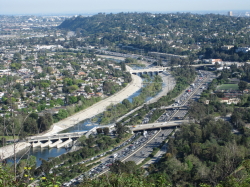
|
Looking south from Beacon Hill toward the L.A. River and the I-5 Freeway.
|
4:50 - Beacon Hill (1,001'). Wow, great views!! The sky is clear, offering above average visibility. I wander around the bald summit and soak in the scenery. A map of Glendale would have been fun to have along, as the city sprawls below me. The blue water of the Los Angeles River stands in odd contrast to the stream of red break lights on the jammed I-5 freeway. I look northeast across the valley to my beloved San Gabriels and am saddened by the horrific devastation of the Station Fire. To the south I can see Catalina Island. I get out my binoculars to get a closer look at the sights and see the office building where I work in L.A. Two ladies with a baby arrive at the summit. They linger and admire the vistas. The ladies leave and a man emerges from a use path that ascends the south ridge from Lower Beacon Trail.
5:15 - Leave Beacon Hill and head back west toward five points junction. Stop to take pictures of wild cucumber and mustard bathing in the sun.
5:21 - Five points junction. Decide to take the left route of the two routes heading west. Figured the loop would add maybe .75 mile to the hike.
5:26 - Vista Del Valle Drive and Joe Klass Water Stop - Nice picnic area with several tables and water. Wander around and check things out. Leave at 5:31, continuing west on the paved road. Take a spur trail that veers to the right toward the water tank.
5:34 - Water tank. No longer in use. Covered with graffiti. Urban grunge meets nature. Head back to the road.
|
|
Looking south from Vista Del Valle Drive.
|
5:38 - Wide paved turn-out at bend in the road. Nice view west of the Griffith Observatory, now in silhouette by the sinking sun. Lot of foot traffic. Strong breeze...strap my hat on. Love the L.A skyline due south. About 100 yards northwest, a trail coming up from the west intersects the road (trail not on Stone's map). This road going north at that point is fenced off and signed: "Closed, No Trespassing, Do not Enter." I suspect the closure is related to fire damage. Check other maps. Appears that also Hogback Trail heads northwest from that junction. Looking around, not sure where my return route begins. Finally find it adjacent to the wide turnout.
5:52 - Leave on return route, first ascend north to the west of the water tank, then bend east and contour back toward five points junction. Nice views north toward Burbank. Pass below the water tank and can see the trail I came up on below me. Stop to take pics of eupatory and monkey flower blossoms basking in the late-day sun. I'm still enjoying the green of spring.
6:04 - Five points junction, for the third time. Determine I still have sufficient daylight to complete the loop. Turn right and descend south on Coolidge Trail. Now I am in the full shade of the mountain. Lighting not conducive now for good pics, put snap a few anyway just to record the route. Back across the canyon, Beacon Hill still catches the last rays of sun. Some dense patches of mustard add yellow highlights to the hillsides.
6:17 - Get call from the wife telling me the toilet is broken. Dang cell phone!
6:25 - Hairpin at furthest point south on this route. Pass the driving range fence and in about 30 feet past the fence the trail forks. The right fork comes up from a trailhead at Coolidge Picnic Area. I veer left and continue north as the trail now ascends. The summit of Beacon Hill looms ahead. Round a hairpin, head back south.
|
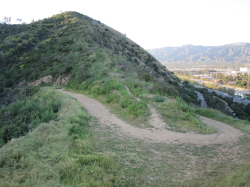
|
Looking north at Beacon Hill from Lower Beacon Trail. That use path heading up the ridge is an alternate route to or from the summit of Beacon Hill, but it is somewhat steep with loose footing in the upper section.
|
6:37 - Hairpin north. Here there is an ascending/descending ridge north with a use trail to Beacon Hill. I deduce that this is the route that the gentleman I met on the summit used. Take my last pics of the L.A. skyline.
6:42 - Continue north, now descending. The trail narrows traversing along the east flank of Beacon Hill. Freeway noisy, paralleling my trail.
6:48 - Start steep ascent and as the trail begins to bend west.
6:53 - Pics of baseball field to immediate north. Can see merry-go-round now. Trip begins final descent—fasten seatbelts and return the trays to their upright position. Last rays of sun still accents the valleys below and distant hills and mountains. Pass a man with a huge dog, not on a lease. There was a lot of people with dogs on the trail today, and thankful, most dogs were on leashes (complying with LAMC 63.44-B,2.C, clearly communicated throughout the park). Unfortunately, some dog onwers feel they are above the rules. (May they be infested with the flees of a thousand dogs!)
7:02 - Trailhead. Yipeee! Exactly three hours from when I first took a picture of this trailhead before looking for my staring point. A wooden post has a number 2 on it. Now of course I can't just go back to my car and go home. I've got to find the correct trailhead for Fern Canyon Trail—the one I missed three hours ago. Finally figure it out. Robert Stone's map of the trailhead detail is quite inaccurate and misleading and doesn't show one trail that converges at this hub of trails (however, Stone's overall map and trail description is good).
I begin ascending Fern Canyon Trail and immediately around the first bend is another junction: the trail to Bee Rock. Oh now I see. Continue up Fern Canyon Trail.
7:14 - Junction of use path coming up from the amphitheater. Now I've completed the whole circle! Sun setting. 7:17 - Start back down.
7:19 - Bee Rock trail junction on the left. Decide to walk a little bit up the trail.
7:22 - Bend west with good views north. Can see old zoo below me. Spot a chain of maybe 20 people climbing straight up a ridge...whoa, what's the about? I continue up the trail for a few more minutes to see if I can find where they mounted the ridge.
7:34 - Bend with good view of Bee Rock, but almost dark now. Find a couple places where the climbers could have used to start their ascent. 7:38 - Ok, it's time to go home.
7:42 - Car. I'm done. About 20 cars still here...more than when I arrived. See a coyote walking across the parking lot. 
Epilog - Perfect weather, clear skies, sweeping vistas, green hillsides, pleasant breezes, fun exploration, and the springtime aroma of the chaparral. What a thoroughly enjoyable outing! I'm certainly drawn to come back soon for more exploring the wonderful springtime trails of east Griffith Park.
 View Large Map / See also Griffith Park Maps page. View Large Map / See also Griffith Park Maps page.
(888 K)
 Beacon Hill Hike Description - Detailed trail guide including driving directions, recommended season, map, notes, links, and photos)
Related links on Dan's Hiking Pages:
-
Hiking Griffith Park - Overview and links to other hikes in Griffith Park
- Griffith Park Maps - A list of links to all the hike maps on this site as well as links to various other maps of Griffith Park
 See my blog posts for hikes to Beacon Hill: See my blog posts for hikes to Beacon Hill:
-
Griffith Park Six Peaks Hike - August 5, 2010 (Bee Rock, Mt. Chapel, Mt. Bell, Mt. Hollywood, Glendale Peak, Beacon Hill via Old Zoo Park)
-
Hogback, Glendale, Beacon in Griffith Park - February 17, 2012 (via Vermont Canyon)
-
Beacon Hill, Glendale Peak and Bee Rock - November 21, 2012
Book Note:
As I noted above in the narrative, the hike description I used for this outing was from Day Hikes Around Los Angeles by Robert Stone (Day Hikes Books: Red Lodge, 2003). Hike 70: "Beacon Hill." I am happy to report that he has corrected the problems with the hike description and published it in his Day Hikes in the Santa Monica Mountains - by Robert Stone (Day Hikes Books: Red Lodge, 2012). Hike 1: "Beacon Hill Loop." The updated hike description and line map are now accurate and reliable.
|