| |

 |
| |
|
| |
 |
| |
 |
| |
 |
| |
 |
| |
 |
| |
 |
| |
 |
| |
 |
| |
 |
| |
Dan's Hiking Pages: Hikes in the San Gabriels and Beyond |
| |
|
|
|
Van Tassel Ridge via Fish Canyon Trailhead
Azusa / Los Angeles County / Angeles National Forest / Southern California
 Hike report: May 1, 2003 Van Tassel Ridge Hike Description Hike report: May 1, 2003 Van Tassel Ridge Hike Description
 My daughter and I hiked from the Fish Canyon trailhead to the boundary of Azusa and the Angeles National Forest on Van Tassel Ridge (1.9 miles one way, 1400' gain).
It took two hours for the climb. My 12-year old daughter was with me up to about 1.6 miles (1800') (1 hour and 37 minutes to this point). Without her, I could have done the total climb to the boundary in 1.5 hours or less.
The dominant word for the trail that came through my mind while hiking was "ridiculous." Actually, if one is an adventurer who wants to explore this prominent high point overlooking nearby foothill communities, the trail provides access. To me, the hike was an interesting adventure in scouting out this ridge which I see every day from our home in Azusa. The views and sense of conquering this 2000-foot ridge summit was worth bushwhacking through mustard and thistle and scrambling up a poorly designed and maintained trail. As a four-mile up-and-back hike, the trek was a worthwhile way to spend an early evening in the spring.
However, to use this trail as an access to Fish Canyon Falls is absurd. When I first hiked to the falls in February 1997, it was a pleasant 5-mile round trip with easy access through the quarry. Really nice outing. But as an 8.5-mile, 3200-foot-elevation-gain hike, it is absolutely ridiculous.
Thank you trailbuilders for giving us an adventurous way to explore Van Tassel Ridge. It is unfortunate that access to a beautiful waterfalls is limited to diehard hikers who are willing to endure the absurd, or to those who join the throng taking advantage of Vulcan's access days. 
Hike Log
Fish Canyon Trail / Van Tassel Ridge
5-1-03
|
|
4:10 pm
|
A: Trailhead (680')
|
|
5:20
|
B: Summit fork
Near "Diamond Head" (1570' 1.3 mi.)
|
|
5:32
|
C: Quarry fence
|
|
5:47
|
D: Ridge Van T canyon view
|
|
6:03
|
E: ANF Boundry (fence)
(2080' 1.9 mi.)
|
|
6:17/:25
|
D: Ridge Van T canyon view
|
|
6:32
|
C: Quarry fence
|
|
5:20
|
B: Summit fork
Near "Diamond Head" (1570' 1.3 mi.)
|
|
7:20 pm
|
A: Trailhead (680')
|
|
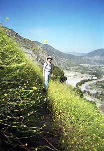
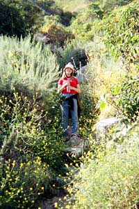 Don't think that the smile was always on her face as we bushwhacked our way up this rediculous trail.
|
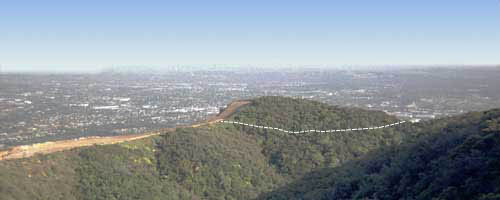
5-1-03 - Looking south at Diamond Head from a steep dozer cut which supposedly is a "trail." The dotted line shows the approximate route of the trail from B to C, traversing the jungle-like area (this "jungle" is pretty withered and arid by mid to late summer).
Note: This is the section that Vulcan plans to mine.
|
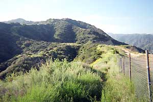
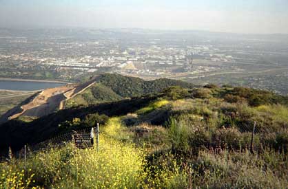
5-1-03 - Looking south on Van Tassel Ridge from the boundry of Azusa and the Angeles National Forest (2080')
|
Related links on Dan's Hiking Pages:
|
|