| |

 |
| |
|
| |
 |
| |
 |
| |
 |
| |
 |
| |
 |
| |
 |
| |
 |
| |
 |
| |
 |
| |
Dan's Hiking Pages: Hikes in the San Gabriels and Beyond |
|
|
Summit 2843
San Gabriel Canyon / Morris Reservoir area
Angeles National Forest / Southern California
|
Trail Stats
|
|
Mileage (r.t.)
|
4.0
|
|
Trailhead
|
1300'
|
|
Summit
|
2843'
|
|
Total loss/gain
|
1543'
|
|
Gain/loss per mi.
|
771'
|
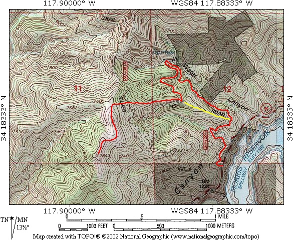
Summit 2843 stands conspicuously at the mouth of the San Gabriel Canyon. The USGS topo map (Azusa quadrant) simply marks it at an elevation of 2843', with no name. I've consider naming it; options include, Sentinel Peak (as it stands guard over the entrance to the canyon), Roberts Peak, Morris Peak, Silver Fish Peak, or Mountain Cove Peak. Since the peak is seen prominently from my home in Azusa, it has called to me for years. I've never seen it written up any place and there are no formal trails to it. But the summit is reasonably achievable, thanks to a deteriorating fire road and some aging fire breaks.
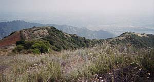
The round-top summit offers a fine 360-degree unobstructed view, taking in the suburban landscape to the south, the rugged beauty of the surrounding front range, and the majestic peaks of the San Gabriel Mountains high country to the north and east.
Since there are very few hiking trials in the lower portion of San Gabriel Canyon, this hike to Summit 2843 offers an interesting opportunity. But keep in mind, after the first half mile, this hike is cross country. A hiking stick and long pants are recommended.

|
|
Looking north toward Summit 2843 from Glendora Ridge above Garcia Trail. Just to the right of the summit is Pine Mt. (4539') and Silver Mt. (3385'). To the far right is snow capped Mt. Islip (8250'). Hwy 39 snakes its way up San Gabriel Canyon.
|
Season: October - May
Most of the hike is devoid of shade, so you will enjoy it most in the winter or early spring when the weather is cool, the visibility is clear, and the hillsides are green. Wear long pants and watch out for tics and rattlesnakes. See Seasons of the San Gabriels for a detailed description of minding the seasons.
Getting to the Trailhead:
 From the 210 Foothill Freeway in Azusa, exit Azusa Avenue (Hwy 39) and head north toward the mountains. It's 1.3 miles to the forest entry station at the mouth of the canyon and another 4.3 miles to the trailhead, about 0.3 mile past Morris Dam. There is a turnout on the left (west) side of the road (mile marker 19.42) with a locked-gated marked 2N28. Park in the clearing, not blocking the gate. From the 210 Foothill Freeway in Azusa, exit Azusa Avenue (Hwy 39) and head north toward the mountains. It's 1.3 miles to the forest entry station at the mouth of the canyon and another 4.3 miles to the trailhead, about 0.3 mile past Morris Dam. There is a turnout on the left (west) side of the road (mile marker 19.42) with a locked-gated marked 2N28. Park in the clearing, not blocking the gate.
 Map to trailhead:
Hwy 39 at 2N28, mile marker 19.42
Map to trailhead:
Hwy 39 at 2N28, mile marker 19.42
No Adventure Pass Needed - Previously a National Forest Adventure Pass was required for parking at this trailhead since it is within the Angeles National Forest. As of September 2016, the Recreation Enhancement Act restricts the requirement for an Adventure Pass to only sites that provide designated amenities, such as picnic tables, toilets, and trash receptacles. Visitors do not have to display a recreation pass if they park outside these sites. See here for more Adventure Pass information.
Trail Description:
 Start your hike by walking past the gate and up the fire road. The USGS topo map labels it as Silver Fish Road, no doubt derived from Silver Mountain and Fish Canyon. The route begins by heading generally in a northward direction, paralleling Hwy 39 and climbing gradually.
After you reach a wide turnout overlooking Hwy 39 and Morris Reservoir, you round the bend and head west into the first canyon. Mature sycamore and oak treat you to shade. The vegetation is thick and the slopes steep, but your wide path climbs gently. As you switch back to the right and emerge from the canyon, you reach an outward bend with a wide turnout, after about 0.5 mile from the start.
|
|
Looking south from Summit 2843 toward Azusa. On a clear day the view of the city is striking. If you hike (4 minutes) down to the high point to the left of the photo you have great views of the canyon mouth.
|
From here you have two options. The scenic, easy-grade route continues on the road contouring into Water Canyon. But you may have to negotiate some obstacles such as trail deterioration, poison oak invading the route, and brush (see alternate routes below for this description).
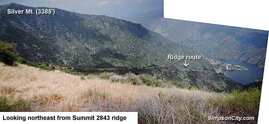
The shortest and most direct route is to go straight up the ridge. A use path follows an old dozer-cut firebreak all the way to the top of the mountain near the summit. The main obstacle of this route is the first 150 yards—it is ridiculously steep with some loose footing. You'll definitely want a hiking pole and lug-soled shoes.
To follow this route (in yellow on the topo map below), round the bend and immediately take a path to the left that climbs up a stone's throw to the ascending ridge. Turn right and climb straight up. The first 150 yards are ridiculously steep. Watch your step, take it slow and easy, and be patient. A hiking stick is most helpful. After this section, the ridge gets more gentle and makes a nice route. Proceed up all the way to the upper ridge, passing over the fire road twice en route (the first passing of the fire road is where it comes up from Water Canyon—see alternate route below).
From the board upper ridge which divides San Gabriel Canyon and Roberts Canyon, turn left (south) and follow the undulating ridge all the way to the Summit 2843, about a 0.5 mile. You will pass by two lesser summits en route. There's not a formal trail, but a web of paths provides an infinite number doable routes. In the fall after the initial rains, the grass is short and green and makes for a nice walk. As the spring season gets later and warmer, the grass gets taller and dryer with lots of pokey things to attack your socks. Be particularly alert for rattlesnakes in the tall grass.
Enjoy your views from the broad summit. To the immediate south and southwest is Azusa and Duarte, separated by the San Gabriel River flowing out of the canyon. On a clear day you can see the Los Angeles skyline to the southwest. To the west you look down into Roberts Canyon, then above to Fish Ridge, Van Tassel Ridge, Mt. Bliss, and Monrovia Peak looming on the skyline. To the immediate north are Silver Mt. and Pine Mt., with Twin Peaks peeking out above. Views of the distant San Gabriel Mountains high country start with Mt. Islip to the north and wrap around to the east to Ontario Peak, with Mt. Baldy standing majestically in the middle. Looking down into the San Gabriel Canyon to the east you see Morris Dam and Reservoir and Hwy 39. As you gaze higher you see Glendora Mountain Road and Glendora Mt. If you would like to take a short side trip, four minutes down the south ridge to the prominent knob will reward you with striking views into the mouth of the canyon and the Mountain Cove residential community.
Return the way you came. 
Hike Log
Summit 2843
11-18-05
|
|
7:34 AM
|
A: Trailhead (1300')
|
|
7:47/7:55
|
B: Ridge route jct
|
|
8:13/8:19
|
C: Road (2N28) 1st crossing
|
|
8:38/8:45
|
D: Road (2N28) 2nd crossing
|
|
8:53
|
E: Top ridge jct
|
|
9:18/10:45
|
F: Summit 2843
|
|
11:02/12:03
|
E: Top ridge jct / exploring west ridge past 2682'
|
|
12:12/12:15
|
D: Road (2N28) 2nd crossing
|
|
12:27
|
C: Road (2N28) 1st crossing
|
|
12:55
|
B: Ridge route jct
|
|
1:10
|
A: Trailhead (1300')
|
|
View Full Topo Map (216 K)
|
Hike Log
|
Summary
(Hiking time)
|
61 minutes up
67 minutes down
(Not all break stops are recorded in the table on the left.)
|
|
Alternate Routes:
-
Water Canyon. At about a half mile into the hike, you'll reach a wide bend and a turnout with views toward Morris Reservoir. As you round the bend, pass the unmarked junction for the ridge route (marked in yellow on the topo map above), and begin to head northwest along the south slope of Water Canyon. Enjoy patches of shade; there will be none on the upper section of the hike. Be careful as you negotiate deteriorating sections of the old road. You'll pass a 12-foot waterfall on the left, only active after rains. The east ridge of Silver Mountain (3385') looms to the north. As the canyon narrows, the forest gets thicker and poison oak gets abundant.
In a few minutes you'll press through a section of thorny little trees, which in the past have hindered passage. The route then cuts back sharply to the left, continuing up the south slope of Water Canyon heading southwest. In a minute you reach a section of thick poison oak. In the past the obnoxious stuff virtually blocked the path, but on my last trip (2-21-15) I was able to pass easily. In the winter when the poison oak has lost its leaves, it's harder to identify, and its branches still contain the toxic oil.
Just minutes past the poison oak patch, you contour around the bend to the right and head west into a tributary canyon. After that you contour into a smaller ravine. After you emerge, you finally reach a bend that curves around an ascending/descending ridge (this is the junction you would reach if you came up the ridge route—in yellow on the topo map above. As an alternate way back, you can follow the use path down the ridge. But use caution on the last 150 yards; it becomes precariously steep with some loose footing). The road beyond this junction point is overgrown and not passable. To continue to the summit, turn right (west) and take the use path straight up the ridge to the upper ridge, passing over the fire road one more time.
-
Saddle and Silver Mountain. While climbing the ascending/descending ridge, you'll reach a second crossing of the file road. If you would like, rather than proceeding up the ridge to Summit 2843, you can turn right (north) and walk to the saddle between Summit 2843 and Silver Mountain. From here, you can climb 0.7 mile, 1,035 vertical feet to Silver Mountain (3385'), a very worthwhile destination. You ascend a reasonably defined use path following the old fire break up the south ridge. It's a steep climb but not precarious.
From the saddle, Silver Fish Road (2N28) continues north and northwest into the upper reaches of Roberts Canyon, then over into Fish Canyon and eventually to White Saddle. Unfortunately, after a couple hundreds yards past the saddle, the road becomes completely overgrown and impassible. I have surveyed the upper reaches of Roberts Canyon and Fish Canyon from a helicopter and have observed that Silver Fish Road is virtually non-existent in many places and extremely dense in others; the rugged chaparral has reclaimed the road from human use.
-
Southwest Ridge Route. This route to Summit 2843 starts at the mouth of Roberts Canyon and the northwest corner of the Mountain Cove residential community and proceeds directly up the ridge all the way to the summit, climbing 2,000 vertical feet in 1.4 miles. It is steep and brushy with no formal trail and no shade. Access to the route is through a private gated community, thus is not readily available to the general public. I took this route on 12-20-05. The weather was pleasant with nice cloud cover. A network of deer paths crisscrosses on and about the ridge all the way to the summit. Some sections are awfully steep with loose footing. The going is slow and tedious. For the most part, the brush was not too thick, but certainly always present and menacing. On the lower two thirds of the route, the dominant plant was coastal sagebrush. On the top section it was California buckwheat. Laurel sumac dotted the route. I can't imagine taking this route without sturdy boots, long-sleeve shirt, long paints, leather gloves, and a walking stick. And my clippers came in useful in the first part of the route forging through a laurel sumac forest as I struggled to find a good route. I started at 6:35 AM. The trip took me 2 hours and 12 minutes up (including 18 minutes of breaks), and 2 hours and 4 minutes down (including 22 minutes of breaks and a short side trip to high point 1389').
 Dan's Hiking Blog:
Trail Link:
- Peakbagger.com - "Peak 2843." Geographic data, topo maps, trip reports
Last Hiked: January 1, 2016
|
|