| |

 |
| |
|
| |
 |
| |
 |
| |
 |
| |
 |
| |
 |
| |
 |
| |
 |
| |
 |
| |
 |
| |
Dan's Hiking Pages: Hikes in the San Gabriels and Beyond |
|
|
Bear Canyon Trail (Old Mt. Baldy Trail)
To Bear Flat and up Baldy's South Ridge
Angeles National Forest / Southern California
Trail Stats
to Bear Flat
|
|
Mileage (r.t.)
|
3.6
|
|
Trailhead
|
4320'
|
|
Bear Flat
|
5580'
|
|
Total gain
|
1260'
|
|
Gain per mi.
|
700'
|
|
|
Trail Stats
Ridge point 7755'
|
|
Mileage (r.t.)
|
7.4
|
|
Trailhead
|
4320'
|
|
Ridge Point
|
7755'
|
|
Total gain
|
3435'
|
|
Gain per mi.
|
928'
|
|
This hike eluded my radar for years. As a self-professed peak-bagger, a three-and-half-mile round-trip stroll to Bear Flat—as described by Jerry Schad—never rose high enough on my priority list. And to use this trail to bag Mt. Baldy sounded more like punishment than an enjoyable day of hiking. John Robinson describes this trial that gains nearly 6,000 feet elevation in three horizontal miles as "one of the most strenuous hikes in the San Gabriels." He says that this "hard way to do Old Baldy" is "unbelievably steep" in spots and guaranteed to leave the hiker "pooped." So this trail was pretty low on my interest list.
However, since I had been running out of readily accessible hikes in the San Gabriels that I had not done, I started taking a closer look at hikes I had previously ignored. And Bear Canyon Trail looked appealing, not as a strenious ascent to Mt. Baldy, or as a casual saunter to Bear Flat, but as a 7.4-mile round-trip hike with 3,435 feet of elevation gain—a most respectable hike for my tastes.
|
|
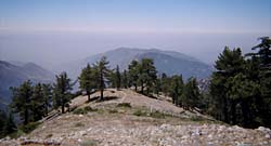
Bear Flat (5580') - Looking south down Bear Canyon. Sunset Peak (5796') is on the left.
|
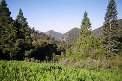
Bear Canyon Trail—also called the Old Mt. Baldy Trail—offers some of the finest scenery and rewarding views in the San Gabriel Mountains high country. The first 1.8 miles to Bear Flat delightfully travels a superb single-track trail adorned with fern under a rich canopy of live oak, bay, and bigcone Douglas-fir. The lively creek gurgles, bubbles, splashes, and cascades down this enchanting canyon. Beyond Bear Flat the trail begins to steeply climb the chaparral-covered southeast flank of Mt. Baldy's great south ridge, You're rewarded with expanding views of Ontario Ridge, Icehouse Canyon, the "Three T's" and Baldy Notch. You'll then enter an open conifer forest with wide-reaching views toward the expansive San Gabriel Mountains to the west. Even without achieving a grand mountain summit, this hike is sure to provide a fulfilling outing for even a diehard peak bagger.
Season: April - November
This is a great spring, summer and fall hike, but also is quite nice in the winter if the trail is free from snow, On a hot summer day, the chaparral section and parts of the ridge route can be torture, so start early while it's cool. See Seasons of the San Gabriels for a detailed description of minding the seasons.
Getting to the Trailhead:
 From the new 210 Freeway extension, driving east: Exit Baseline Road in Claremont. Turn left on Baseline. In one block turn right unto Padua Avenue. In 1.7 miles turn right onto Mt. Baldy Road (stop sign). At 7.1 miles you reach the intersection of Bear Canyon Road (coming in from the left) at the Center of Mt. Baldy Village (in another one tenth of a mile you pass the Angles National Forest Mt. Baldy Visitor Center).
From the new 210 Freeway extension, driving west: In Upland, exit Mountain Ave./Mt. Baldy Exit, Exit 54. Turn right and proceed north on Mountain Ave. Drive 5 miles to Mt. Baldy Road.
Turn left on Bear Canyon Road and find a parking place immediately on the right. On the left is the Village Chapel, so please respect their parking rights. There is also a small parking area up the road a 0.15 mile. Another option is to park directly in front of the Visitor Center on the Street or across the street. Please do not park in the parking places designated for Mt. Baldy Lodge; we need to respect local businesses and other private property. A National Forest Adventure Pass is required for parking.
Trail Description:
 Walk up the paved Bear Canyon Road past an assortment of cabins along the way. In 0.4 mile you'll reach the end of the road and the beginning of the trail. Cross the creek and follow the trail as it heads up canyon in a northward direction. After about 10 minutes the trail splits, I recommend going to the right, up the slope, the main route (the route going straight crosses the creek, climbs steep rustic rock steps, passes several old cabins, crosses the creek again and climbs steeply to rejoin the main trail). In a bit you'll pass a water tank on the left. You may be surprised to see some poison oak en route—in general it does not grow above 5,000 feet. But the hike starts at 4,320 feet, so we are within the top end of poison oak growing range.
The trail switches back south and climbs the slope to an open stretch with nice views down toward Baldy Village and beyond. You don't stay in the open sun for long as the trail loops back and again enters the shade of the main canyon, high above the stream. At 1.8 miles from the start of your hike, you'll cross the creek and arrive at Bear Flat (5580'), a small, fern-covered, sloping meadow. If this is your final destination—at 3.6 miles round trip—snoop around a bit and then return the way you came.
To continue on, follow the trail as it crosses Bear Flat and begins to zigzag up the southeast flank of Baldy's south ridge. You'll notice the trail is steeper than the first section of the hike. The chaparral, which burned in the 2008 Big Horn Fire, provides no shade. As you climb, look back for a bird's-eye view of Bear Flat.
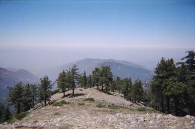
The reward for your sweat is the expanding views of the surrounding high country. The large mass towering on the southeast is Ontario Ridge and Ontario Peak (8693'). Due east you look straight up Icehouse Canyon toward Icehouse Saddle and crowned with Timber Mountain (8303'), the southernmost peak of the popular "Three T's." The dominant double peak to the left of Timber is Telegraph Peak (8985'). And the smaller mound to its left is Thunder Mountain (8587'). With binoculars you can see the ski-lift tower on its top. And further to the left, the lowest spot on the ridge is Baldy Notch. (View labeled photo of view east)
|
|
Looking south toward the Bear Canyon Trail, high on the ridge from just below the 7755' point, off trail. View Large image.
|
You can stop and turn around at any point, but I'd recommend continuing on at least until you achieve the crest of the main ridge and soak in the views to the west. Just before reaching the main ridge, tall conifers begin to dominate forest.
The trail snakes up the broad hog-back ridge with spectacular views alternating in three directions. (View west) To round off the hike at 7.4 miles round trip, your destination will be a broad saddle on the ridge just past the high point marked 7755 feet on the topo map. Enjoy a lunch while sitting on the rocks in the shade. Return the way you came. For a little variation, from the saddle, follow the broad ridge south a couple minutes to the 7755-foot welt. You can double back or continue down the ridge off trail to reach the main trail in a few minutes. (If you would like to hike all the way to Mt. Baldy see my hike description: Mt. Baldy (10,064) via Old Mt. Baldy Trail.) 
 View Topo Map (224 K)
Trail Notes:
-
Permits: A National Forest Adventure Pass is required for parking. You can obtain it from the National Forest visitor's center in Mt. Baldy Village (909-982-2829).
-
Mileage and elevations:
|
Trail Stats USFS - Fact Sheet - Mt. Baldy Visitor Center
|
|
|
One-way
|
Elevation
|
|
Bear Canyon Trail
|
Distance
|
Start
|
End
|
Gain
|
|
Visitor Center to Mt. Baldy
|
6.4
|
4260'
|
10,064'
|
5804'
|
|
Visitor Center to Bear Flat
|
1.75
|
4260'
|
5530'
|
1270'
|
|
Bear Flat to Mt. Baldy
|
4.65
|
5530'
|
10,064'
|
4534'
|
The Mt. Baldy Visitor Center provides a fact sheet with trail stats (see right), which corresponds with the 2002 Tom Harrison map—Angeles High Country Trail Map. The 2009 (Mt. Baldy & Cucamonga Wilderness) and 2011 (Angeles High Country) maps put the trailhead elevation at 4320 and the mileage to Bear Flat at 1.8 miles. I use the Harrison Maps mileage and elevations when available. My stated distance (3.7 miles) from the trailhead to ridge point 7755' is an estimate based on study of the topo map and GPS reading.
-
Trail name: The USFS fact sheet refers to the trail as Bear Canyon Trail, as does the signage on the trail (7W12). The Tom Harrison map calls it the Mt. Baldy Trail while the USGS topo map labels it simply Baldy Trail. Jerry Schad refers to it both as the Bear Canyon Trail and the Bear Flat Trail. John Robinson calls it the Bear Flat Trail or Old Mt. Baldy Trail.
-
People traffic: John Robinson says of the trail that "few use it nowadays." However, the several times I've been on the trail I observed lots of people on the trail. For example, on 7-9-05 I encountered more than 30 other hikers, and all but about five were heading to the summit! And most of the summiters had made this hike multiple times. Many that I spoke with were doing the hike as training for a High Sierra hike. On 9-17-11, on a hike all the way to Baldy, I estimate that I encountered more than 40 people. So, the trail certainly doesn't provide the solitude that Robinson hints too, but the shire expanse of the mountain tends to dissipate 20 to 30 people spread out over miles of hiking.
- High point - If you are tempted to be disappointed that you don't reach Baldy summit, just remember that the hike reaches a ridge point (7755') that is higher than the highest points in 36 states! In fact, even if you did reach the summit, you would only add one more state to the count! See United States State High Points from peakbagger.com.
- Trail Closure -
In August 2014, a thunderstorm damaged Mt. Baldy Trail above Bear Flat. As a result, the Forest Service closed the trail effective August, 21, 2014 to August 20, 2015. The damage was not significant but inexplicably the FS failed to remedy the situation expeditiously and thousands of hikers were denied one of the very best trials in the San Gabriels for an entire year. The closure order expired and the trail was reopened on August 21. On August 20, ANF tweeted: "Although, Mt. Baldy Trail reopens tomorrow, we ask visitors to wait until an assessment can be done. http://go.usa.gov/36bHF." Really? They drag their feet for a year than have the audacity to ask hikers to voluntarily wait until the FS gets around to doing an assessment? Really?!
Related links on Dan's Hiking Pages:
Links:
- Hundred Peaks Section, Angeles Chapter, Sierra Club Peak 16D "Mount San Antonio" - Gives brief description of 4 routes to Mt. Baldy. Route 3 is the Bear Canyon Trail (although they don't identify it as such). Puts distance to peak at 12 miles round trip, 6000 feet gain. Incorrectly puts the distance to Bear Flat at 1 mile (probably does not take into account the .4 mile walk on the road and loses another .25 mile).
- LDPhotography.net - Baldy and West Baldy - by Lonnie De Cloedt (aka Thomas Canty). Nice photo album with captions and topo map of his hike up the Bear Canyon Trail on July 28, 2005.
-
Photo Albums on Webshots.com
Books:
- Afoot and Afield in Los Angeles County - by Jerry Schad (Wilderness Press: Berkley). Area A-12, Trip 4: "Bear Flat." Excellent trail description to Bear Flat. Puts distance at 3.5 miles round trip, 1,300 feet elevation gain.
- Trails of the Angeles: 100 Hikes in the San Gabriels - by John Robinson (Wilderness Press: Berkley). Hike 92: "Mt. Baldy Village to Mt. San Antonio and Baldy Notch." Provides an interesting historical background and a hike description to Baldy summit (Puts elevation gain at 6000 feet). He puts the distance to Bear Flat at 1.5 miles (although it's unclear whether that is from parking lot or the beginning of the trail. He describes Bear Flat as a "small mountain meadow clothed in a carpet of lush grass." I love Robinson's writing, but here's one of those places where his description does not match present reality. You'll find no grass carpet here, just a sloping chaparral-free space filled with waste-high bracken fern, yerba santa, and a dandelion-type flower with large puffer balls. And contray to Robinson's claim that few people use this trail nowadays, this trail is indeed popular with lots of foot traffic.
Last Hiked: September 17, 2011 (to Mt. Baldy)
|
|