| |

 |
| |
|
| |
 |
| |
 |
| |
 |
| |
 |
| |
 |
| |
 |
| |
 |
| |
 |
| |
 |
| |
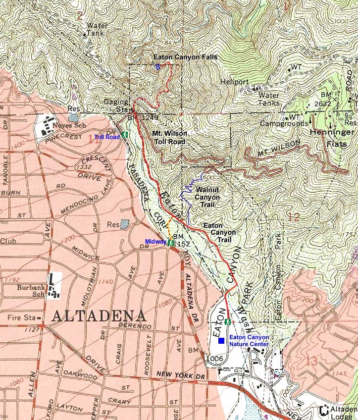
Dan's Hiking Pages: Hikes in the San Gabriels and Beyond |
|
|
 Eaton Canyon Falls
via Eaton Canyon Nature Area
Altadena / Angeles National Forest / Southern California
|
Trail Stats
|
|
Mileage (r.t.)
|
3.0
|
|
Trailhead
|
980'
|
|
Bridge
|
1250'
|
Falls
|
1350'
|
|
Total loss/gain
|
400'
|
|
Gain/loss per mi.
|
266'
|
On a hot August day in 1877, John Muir set out from Pasadena for an expedition into the San Gabriels. He writes: "On the first day of my excursion I went only as far as the mouth of Eaton Canyon, because the heat was oppressive, and a pair of new shoes were chafing my feet to such an extent that walking began to be painful. While looking for a camping ground among the boulder beds of the canyon, I came upon a strange, dark man of doubtful parentage. He kindly invited me to camp with him, and led me to his little hut. All my conjectures as to his nationality failed, and no wonder, since his father was Irish and mother Spanish, a mixture not often met even in California. He happened to be out of candles, so we sat in the dark while he gave me a sketch of his life, which was exceedingly picturesque."
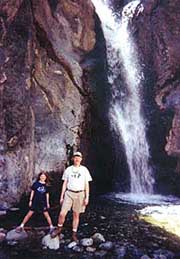
The next morning, Muir recounts, "Half an hour's easy rambling up the canyon brought me to the foot of "The Fall," famous throughout the valley settlements as the finest yet discovered in the range. It is a charming little thing, with a voice sweet as a songbird's, leaping some thirty-five or forty feet into a round, mirror pool. The cliff back of it and on both sides is completely covered with thick, furry mosses, and the white fall shines against the green like a silver instrument in a velvet case."
 Today, more than 140 years later, Eaton Canyon Falls still holds great appeal, save the graffiti. This destination is exceedingly popular. On a warm Monday holiday in February, I encountered hundreds of people on the trail. However, on a cool Wednesday morning in February, I was able to enjoy the whole scamper from the bridge to the falls and back to the bridge all by myself—quite a contrast from the crowds I've experienced.
The hike described below starts at the Eaton Canyon Nature Area, follows the canyon trail 1.1 miles to the Mt. Wilson Toll Road bridge, then scrambles up streambed 0.4 mile to the falls. The grade is gentle, climbing only about 400 feet in a mile and a half. There are shorter routes (see alternate routes below), but this one offers a splendid saunter along Eaton's wide, boulder-strewn wash, and avoids a steep climb out of the canyon. This is a good family hike, but little ones may need some assistance in the last half-mile scramble, with many creek crossings and some climbing over rocks. In the rainy season, creek crossings can be dicey and getting your feet wet may be unavoidable. Be careful. And be vigilant in avoiding poison oak.
The Eaton Canyon watershed is large enough to usually provide a year-around water flow over the falls, however, the showiest time would be in the winter and spring after some good rains. You will want to avoid it immediately after a big storm unless you are prepared for potentially dangerous stream crossings.
Season: November - June
The best season is in the spring when the weather is pleasant, the chaparral is green, flowers are blooming, and the water is flowing briskly. Some authors (Schad, McKinney) rate the hike as all year. But I agree with Ann Marie Brown. The hike is mostly in open sun with lots of reflective rock. Midday in the summer can be most uncomfortable, unless you go early morning or early evening. See Seasons of the San Gabriels for a detailed description of minding the seasons.
Getting to the Trailhead:
 From the I-210 Foothill Freeway eastbound driving through Pasadena, exit at Sierra Madre Blvd./Altadena Drive. Turn left (north) at the first light (Altadena Drive). From the I-210 Foothill Freeway eastbound driving through Pasadena, exit at Sierra Madre Blvd./Altadena Drive. Turn left (north) at the first light (Altadena Drive).
From the I-210 westbound, exit at Sierra Madre Blvd./San Marino. Turn right (north) at the second light (Altadena Drive).
Follow Altadena Drive about 1.5 miles to New York Drive. Continue up Altadena a half block and turn right into the entrance to Eaton Canyon Nature Area Park. Follow the drive around to the parking area. For the hike, you'll want to park at the farthest end of the lot, however you may want to first visit the Nature Center, open 9 a.m. to 5 p.m. Tuesday through Sunday. The park and trails are open daily from 7:30 a.m. to 5 p.m.; closed Christmas and New Year's.
 Address: 1750 N Altadena Drive, Pasadena, CA 91107
Trail Description:
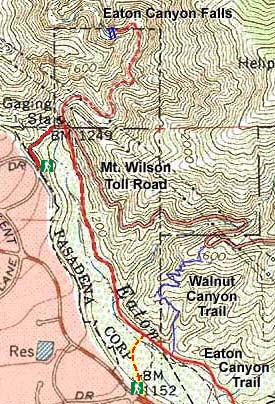
 From the parking area, follow the wood-chip-covered path heading up canyon. In a few minutes, veer to the right and follow the path across the wide creek bed to the other bank. Turn left and continue on the wide path as it travels along the terrace above the wash. Enjoy a few patches of shade provided by oaks and sycamores. At a half mile, you pass the junction for Walnut Canyon horse trial (an alternate route for accessing Mt. Wilson Toll Road). In few minutes you'll see the results of the record storms of Fall 2004 through the winter, where the torrents eroded deeply into the east bank, altering the trail route. In a few more minutes you pass along the base of the huge slide that forced the closure of the old toll road above. In a couple more minutes you reach a junction with a sign, "Eaton Canyon Falls, 1/2 mi." Veer left (the right fork takes you up to the bridge). Pass under the bridge (Schad and Brown indicated to climb to the bridge top then drop back down, but the best route is to go under the bridge).
|
April 1, 2000
Eaton Canyon Falls via the Eaton Canyon Nature Center
Christa and Dan made this leisurely hike with her Girl Scout troop, three miles round trip.
|
The bridge starts your half-mile creek scramble. You will immediately pass the concrete remains of an old gaging station. As you continue up canyon, the route crosses the creek many times (I counted 9), tied together by short stretches of rustic trail. Creek crossings can be dicey in the wet season, so be careful. The streambed bends and winds through a narrow gorge of shire canyon walls (McKinney notes that early Spanish settlers called the canyon "El Precipio"). Except for a few patches of oaks and alders out of reach of the floodwaters, the canyon is like a desert. Finally, after a creek crossing just before the canyon turns sharp left, you round the bend and are treated to your first glimpse of the falls. Two more crossings and you're there.
Volumes of water tumbling 40 feet create a delightful retreat. Plenty of smooth rocks provide ample seating for a nice picnic (please take all your trash back out with you, including your orange peels). The green wading pool makes for fun splashing around on a warm day. The precipitously steep canyon walls and formidable waterfall cause me to wonder how John Muir could have possibly continued up stream.
Return the way you came. 
Notes:
-
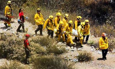 Deadly Eaton Canyon: In recent years, Eaton Canyon has had a number of tragic deaths and serious injuries as well as a host of other incidents. According to the Eaton Canyon Nature Center, on average, hikers are rescued weekly from this area. One reason is that many who are attracted to the canyon are not real hikers. They are simply folks who decide to take a stroll to a waterfall. Some of them are young people who ignorantly decide to climb the treacherous canyon walls to get above the first falls, and they fall to their death. One official suggests that the increase in fatalities is related to a number of social media websites which describe how to climb to the second falls. But the route is perilously dangerous and ignorant people get killed on it. Let me underscore that the hike following the streambed to the falls is completed safely by thousands of visitors a year. The risks are limited to the typical injuries related to stream crossings, poison oak, and sun exposure, all of which are acceptably mitigated by exercising care and being equipped for a hike. The real danger is when people attempt to climb the canyon walls. Read a sampling of Eaton Canyon news stories.
-
Mileage and Elevation: The Eaton Canyon Nature Center sets the distance from the center to the bridge at 1.1 miles, and from the center to the falls at 1.5, thus 3.0 round trip. McKinney and Brown agree. Schad's mileage estimate is 3.4 round trip. I don't know why the difference, except perhaps the half mile of creek walking is indeed longer than traditionally accepted, due to the numerous creek crossings. One popular hiking website puts the mileage at 3.5 round trip, and another puts it at 3.8. For the elevations, I use Schad's numbers, although he puts the trailhead at 980' whereas the Center puts it at 960'.
-
History: Eaton Canyon was named after Judge Benjamin Eaton, who built the first Fair Oaks Ranch House in 1865 not far from Eaton Creek. Judge Eaton was the first to use irrigation from the creek to grow grapes on the slopes. He was also instrumental in the development of the Mount Wilson Toll Road in 1891, and proposed a tramway to Mount Wilson, which later was built to Mount Lowe instead. Source: Eaton Canyon Nature Area website. Visit their website to read more history.
-
Alternate routes: Besides the 3-mile hike described above, there are two shorter options for hiking to Eaton Canyon Falls:
 Toll Road/Pinecrest (1.4 miles r.t.).
Address: 2267 Pinecrest Drive, Altadena, CA 91001
Driving directions: From Eaton Canyon Park, turn right unto Altadena Drive and drive about 1 mile and turn right unto Crescent. Go about 200 yards to Pinecrest, turn right and go about 200 yards to the Mt. Wilson Toll Road, on your right. Parking on the weekends is restricted, so mind the signs. You may need to park a few blocks away. Be respectful of the residents. There is a large fence and gate through which you will walk. The hours are sunrise to sunset.
Hiking directions: Pass through the gate and down the road about 0.2 mile. Cross the bridge and veer right. You can use the steep path immediately on the right to descend directly from the end of bridge to the canyon-bottom trail, or you can continue on the road briefly to find a couple other routes that are more gentle. Once at the canyon-bottom trail, proceed up canyon under the bridge, following the directions from the main hike description above.
Midway trail/Midwick Drive (2.2 miles r.t.).
Address: 2202 N. Altadena Drive, Altadena, CA 91001
Driving directions: From the Eaton Canyon Park, turn right unto Altadena Drive and drive about 0.5 mile to where Roosevelt Avenue and Midwick Drive intersect on the left. The trail begins at the pedestrian gate on the right.
Hiking directions: Pass through the gate and follow the trail as it drops to the canyon bottom. Cross the creek bed to intersect the main trail on the east bank (0.2 mile). Turn left (north) and walk the path to the bridge (0.4 mile). Before reaching the bridge, at a signed fork, veer left to stay on the canyon trail to pass under the bridge, following the directions from the main hike description above.
Hike Log
Eaton Canyon Falls
via Eaton Canyon Nature Center
2-15-06
|
|
10:54
|
A: Trailhead (980')
|
|
11:05
|
B: Walnut Cyn Junction
|
|
11:18
|
C: Bridge
|
|
11:42/12:00
|
D: Eaton Falls (1350')
|
|
12:22/12:29
|
C: Bridge
|
|
12:43
|
B: Walnut Cyn Junction
|
|
12:57
|
A: Trailhead (980')
|
|
Summary:
|
48 Minutes up
50 minutes down
|
 View Full Topo Map View Full Topo Map
(356 K)
|
|
Related links on Dan's Hiking Pages and Blog:
Links:
- Adventure Hikes and Canvoneering in the San Gabriels by Christopher E. Brennen. "Hike D5. Lower Eaton Canyon." Presents thorough information on a cross-country hike dropping into the canyon from the north ridge above Henninger Flats. This route requires significant technical skills and equipment. Provides topo map and photos.
- John Muir Writings Steep Trails, Chapter 11, The San Gabriel Mountains - Read the complete account of Muir's excursion into the San Gabriels.
-
 Eaton Canyon Nature Center - Eaton Canyon Park has a beautiful nature center and trails which serve as a primary venue for honing my plant identification skills. The 7,600 square-foot building contains many fascinating displays, live animals, offices, classrooms, an auditorium, restrooms, and an information desk/gift shop. The Center is open from 9 a.m. to 5 p.m. Tuesday through Sunday. Their website provides a brief description and aerial photograph of trails in Eaton Canyon, an online catalog of plants of Eaton Canyon, and more. They put the height of the falls at 50 feet, contrary to all of the credible authors who put it at 35 to 40.
Books:
- Afoot and Afield in Los Angeles County - by Jerry Schad (Wilderness Press: Berkley, Second Edition, Sept. 2000). Area A-6, Trip 6: "Eaton Canyon Falls." Brief trail description. Puts the round trip at 3.4 miles and the falls height at 35 feet. .
- Los Angeles County: A Day Hiker's Guide - by John McKinney (The Trailmaster, 2006). "Eaton Canyon." Historical background and trail description. Puts the round trip at 3.0 miles. Previously published in Wild L.A.: A Day Hiker's Guide (2003), now out of print.
- California Waterfalls by Ann Marie Brown (Moon, 2011) - A guide to 200 waterfalls in California. She writes up 14 waterfalls in the San Gabriels and gives Eaton Canyon Falls a rating of 7 (6=good, 7=great, 8=excellent, 9=spetacular 10="Top 20 in California")—Would be a 9 or 10 if it weren't for the graffiti. Trail description. Puts the round trip at 3.0 miles and the falls height at 40 feet.
Last Hiked: February 15, 2010
|
|