| |

 |
| |
 |
| |
 |
| |
 |
| |
 |
| |
 |
| |
 |
| |
 |
| |
 |
| |
 |
| |
 |
| |
Dan's Hiking Pages: Hikes in the San Gabriels and Beyond |
|

|
Henninger Flats and Summit 3631
Old Mt. Wilson Toll Road, Altadena
Angeles National Forest / Southern California
 Hike Report: June 29, 2008 Hennniger Flats Hike Description Hike Report: June 29, 2008 Hennniger Flats Hike Description
I had not hiked to Henninger Flats since before the 2002 landslides, so I decided I'd give it another look. This is not a hike I'd want to do in hot weather, so I hit the trail early to beat the heat. I first drove over to the Mt. Wilson Toll Road trail trailhead to see the big side.
6:35 AM - Begin hike. From the Roosevelt/Midwick trailhead, I hike down to and across the wash and arrive at the "horse trail" at the mouth of Walnut Canyon. There are no signs indicating a closure.
I navigate the 12 switchbacks of the horse trail and arrive at the old Mt. Wilson Toll Road (at the one-mile marker), 23 minutes from the start (the huge landslide is about 3/4 mile down the road from here). I turn right and head east up the road.
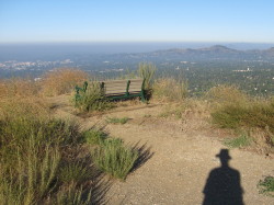 Within 2 minutes I reach the first of several landslides. The well-worn trail passes easily and safely over it. About 7 minutes later I pass over the next landslide, just past a switchback, with no problems. In 13 minutes more I pass by a smaller slide and 5 minutes later another minor slide. And in 5 more minutes I arrive at a large slide. One spot in the path passing through this slide is a little steep and awkward, but not precarious. After passing the slide is a "Danger Road Closed" but clearly it is intended for vehicular traffic that might be coming down the road. A couple minutes passed the big slide is the last switchback and another 7 minutes to my destination.
7:48 - Henninger Flats, 73 minutes from the start. There is a small sign saying, "Henninger Flats is Closed Until Further Notice." There's also a sign a posted on a bulletin board near the visitor center at Henninger:
VISITOR INFORMATION
Henninger Flats continues to remain closed due to the storm damage of 2005. As a result the campgrounds, visitor center and restrooms remain closed.
There is NO CAMPING at Henninger Flats.
Nature trails are also closed for safety due to erosion damage. If you would like further information, please ask the on duty forester or call (626) 794-0675.
Idlehour trail head is approximately 1.5 miles up the Mt. Wilson Toll Road, with a 1.5 mile hike into the campground. The road continues to Mount Wilson for approximately 6.5 miles. Watch out for vehicles.
|
This implies to me that we are welcome to pass through there en route to other places, we just aren't allowed to use the facilities. It also implies that hikers will be hiking up the "closed" road, and gives no prohibition against it. A couple years ago when I spoke with one of the foresters, he said they were strictly enforcing the closure of the road and issuing citations for trespassers. That does not seem to be the case now. Official vehicles are parked at the office, but no one came out to expel the 10 or 12 of us who are picnicking or walking around. I was kind of hoping an official would confront me for hiking up the "closed road," just so I could press back and test the mettle of their resolve to prohibit the public from being there. Since there was no close sign anywhere on the route I hike, they would have no grounds from citing me.
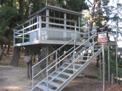 I stroll around checking things out. The campsites and paths around the campground are a little overgrown and clearly show several years of non use. But water faucets are still working. I've long had an affinity for fire lookouts, so I spend some time exploring the tower that's on display. It was moved here from Castro Peak in the Santa Monica Mountains where it stood from 1925 to 1971. See my fire lookouts page.
After looking around the flats, I continue north up the road to a junction on the ridge with views overlooking Henninger Flats and views north. To the left the road heads west about 0.3 mile to a helipad. I've gone that route before. I decide to turn right and continue up the Toll Road. I pass the Idlehour Trail junction (about 1.5 miles from the flats) and climb several long switchbacks to a saddle (3580'). I leave the road, turn left, and climb southwest up an old firebreak.
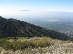 9:15 - Summit 3631'. What a great view and very worthwhile destination! I had looked at this summit for years from the valley below with the intent of someday conquering it. I forge along the ridge west to the second summit of the dual-summit ridge. Lots of stickers in my socks from dry, weedy grass. The white blossoms of California buckwheat are abundant. I have a view straight down to the southeast section of Henninger Flats. Human sprawl fills the southern panorama, but is muted somewhat by June gloom. Distant Saddleback looks like an island jutting up from the marine layer. To the north, framed between pines, Mt. Markham and San Gabriel Peak define the skyline. After an hour of enjoying this splendid location, I return the way I came.
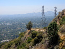 I reach the junction to Idlehour Trail and I decide to check out the trail for a bit. I head north and in 13 minutes I achieve a saddle (about 0.2 mile east of Summit 3446). Vegetation obscures the views but I enjoyed the scenery getting here. I retrace my steps back to the Toll Road and descend back to Henninger. I douse myself with cool water and tend to my feet preparing for the trip down the road in open sun on a day that is getting to be quite hot (I hadn't intended to hike beyond the flats).
I leave the flats at 12:45. My descent is in full sun, which provides completely different lighting for pictures. I retrace my steps down the horse trail, cross the wash, and end at the Midway trailhead.
2:10 - Finish the hike, about 8 miles round trip with 2,550 feet of elevation gain.
In summary, there are 5 slides between where the horse trail reaches the toll road and Henninger Flats. They all appear to be stabilized and users have carved well-worn use paths through them. They will need some heavy earthmoving and engineering to get the road back in service for vehicles, but for pedestrians, the route seems perfectly fine. I think the reason for the closure now is simply government bureaucracy to cover their butts.
Epilog - Very enjoyable hike. I've been to Henniger Flats several times before, but it was very gratifying to explore some new places. And it was good to survey the damage. I wonder if they will ever get the road back open for vehicals, but I'm not eager for it; I like the more rustic feel of trip to Henninger Flats. 
Hike Log
Henninger Flats & Beyond
6-29-08
|
|
6:35 AM
|
A: Trailhead - Midway Trail (1152')
|
|
6:58
|
B: Toll Road / Trail Jct
|
|
7:27
|
C: Mile 2
|
|
7:48/8:00
|
D: Henninger Flats (2550')
|
|
8:10
|
E: Ridge Jct (2890')
|
|
8:36
|
F: Idlehour Jct (3140')
|
|
9:03
|
G: Saddle (3580')
|
|
9:15/10:17
|
H: Summit 3681
Explore west summit
|
|
10:23
|
G: Saddle (3580')
|
|
10:47
|
F: Idlehour Jct (3140')
Hike trail to ridge
|
|
11:00/11:10
|
Ridge (3380')
|
|
11:21
|
F: Idlehour Jct (3140')
|
|
11:34
|
E: Ridge Jct (2890')
|
|
12:05/12:45
|
D: Henninger Flats (2550')
|
|
1:09
|
C: Mile 2
|
|
1:37
|
B: Horse Trail Jct
|
|
2:10
|
A: Trailhead (1152')
|
|
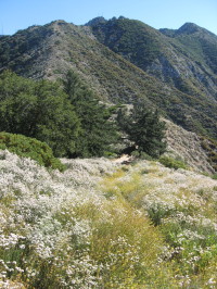
View northest toward the saddle (3580') from near Summit 3681
|
Related links on Dan's Hiking Pages:
|
|