| |

 |
| |
 |
| |
 |
| |
 |
| |
 |
| |
 |
| |
 |
| |
 |
| |
 |
| |
 |
| |
 |
| |
Dan's Hiking Pages: Hikes in the San Gabriels and Beyond |
|

|
Rattlesnake Peak (5826')
East Fork / Angeles National Forest / Southern California
|
Trail Stats
|
|
Mileage (r.t.)
|
8.5
|
|
Trailhead
|
2300'
|
|
Rattlesnake Peak
|
5826'
|
|
El. gain
|
3526'
|
|
Gain per mi.
|
830'
|
Rattlesnake Peak has a distinction of being one of the most inaccessible peaks in the San Gabriels, along with Iron Mountain (8007'), its neighbor to the east.
I have not yet hiked Rattlesnake Peak, but it's on my hit list. Its pointed summit and distinct silhouette lures me, and its notoriety as a difficult destination makes it even more enticing to me.
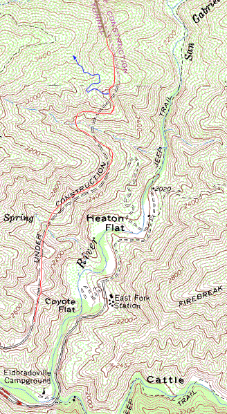
I have, however, hiked the first half mile of the route after it departs from Shoemaker Canyon Road. Shoemaker is a well-graded dirt road penetrating several miles up the East Fork San Gabriel River, on the east-facing slope hundreds of feet above the river. But for a trip to Rattlesnake Peak, you'll be on the road for only a mile and a half.
Christopher Brennen (see links below) estimates the hike distance to Rattlesnake Peak to be 7 miles round trip with 3,500 feet of elevation gain. That comes to 1,000 feet per mile of gain, and that's steep. The Sierra Club Hundred Peaks Section puts the mileage at 9 miles and 3,700 feet elevation gain. Jerry Schad puts the round trip at 8.4 miles. The trailhead is 2,300 feet and Rattlesnake Peak is 5,826 feet, a difference of 3526 feet.
For complete hike descriptions, visit The Sierra Club Hundred Peaks Section and Christopher Brennen's Adventure Hikes and Canyoneering in the San Gabriels (see links below).
Season: October through May
This hike is almost entirely in the open with no shade or water, and is ridiculously steep. Avoid hiking this trail in hot weather. See Seasons of the San Gabriels for a detailed description of minding the seasons.
Getting to the Trailhead:
 From Interstate 210 in Azusa, take Azusa Avenue (Hwy 39) north about 12 miles to the junction at the East Fork Road (8.6 miles from the forest station at the mouth of the canyon). Turn right (east). Cross the bridge and drive 3.3 miles to Shoemaker Canyon Road on the left. Turn left unto Shoemaker Road and drive 2 miles on the paved road to the locked gate. Park in the parking area. No Adventure Pass Needed as of September 2016. See here for more Adventure Pass information From Interstate 210 in Azusa, take Azusa Avenue (Hwy 39) north about 12 miles to the junction at the East Fork Road (8.6 miles from the forest station at the mouth of the canyon). Turn right (east). Cross the bridge and drive 3.3 miles to Shoemaker Canyon Road on the left. Turn left unto Shoemaker Road and drive 2 miles on the paved road to the locked gate. Park in the parking area. No Adventure Pass Needed as of September 2016. See here for more Adventure Pass information
 Map to trailhead:
Shoemaker Canyon Road
Partial Trail Description:
 Walk past the locked gate and head north up the road. Walk past the locked gate and head north up the road.
As you walk, occasionally you'll want to scale the berm on the right to get views east down into the canyon. At about 10 minutes there's a flat area on the left just past the large two-sided road cut. In a certain seasons there is a colony of bee hives. At 20 minutes there's a nice view down to the Heaton Flat campground. When the campground is in use, you can hear voices of loud campers. Heaton Flat Trail can be seen snaking up the canyon east from the campground. After another 15 minutes you'll arrive at the gully described in the Sierra Club 100 Peaks Section as the route junction for Rattlesnake Peak.
The Sierra Club Hundred Peaks Section gives this description:
"From the parking area (2300'), pass the gate and hike up the road 1.5 miles to a gully shortly before a deep two-sided road cut. If you can see the entrance to the tunnel you have gone too far."
Clarification:
- Earlier HPS reports mentioned the road to be washed out. As of 6-14-03, the road was not washed out and there seems to be no indication that it has been washed out in recent years.
- Just past the gully (couple hundred feet) is a large two-sided road cut from where the tunnels come into view, first the second tunnel at a distance, and then the first tunnel up ahead. See aerial photo (88K)
The description continues:
"Go up the steep left bank of the gully and pick up an old overgrown road."
Clarification:
On the right side of the gully is a route that looks much better than the steep slope on the left. But the right side abruptly ends in a 150 feet. Take the route to the left. It's not as hard as it looks. It's worse coming down.
The description continues:
"Follow this up around to the right as it crosses the gully and comes to a flat area with a ridge going up on the left. Leave the road and go up this ridge northwest to where it turns left...."
Clarification:
- The brush is thick and nasty. Be prepared.
- The "flat area" is at the entrance to a two-wall road cut.
- The route up the ridge is easy to follow, but it's pretty steep in places with loose footing (at least for the quarter mile that I climbed). Be prepared for a grueling hike. Coming down is worse. Trekking poles a real help.
Route Condition Update
The Williams Fire 2012 started on Sunday, September 2 on East Fork Road and before it was contain 10 days later, incinerated 4,192 acres of the Angeles National Forest, including Rattlesnake Peak and surrounds. Much of the route to Rattlesnake Peak was completely burned and the brush was reduced to dead sticks. Therefore trail write-ups that were posted prior to the fire describe thick brush. It is a very different scene today. A report at Iron Hiker provides some description and photos of a hike to Rattlesnake Peak on March 15, 2013, six months after the fire.

|
Shoemaker Canyon Road.
The red line shows the road based on aerial photos and field observations. Notice that actual route is different from the USGS top map. It appears that the map shows the road route that was planned rather than that which actually exists.
The blue line shows that first part of the Rattlesnake Peak route. Be prepared for bushwhacking through nasty brush.
As you walk along Shoemaker Road, if you come into eyesight of the tunnels, you've past the Rattlesnake Peak junction.
See aerial photo (88K)
|
 Hike Report: June, 14, 2003
| Hike Report: June, 14, 2003
|  View Slide Show

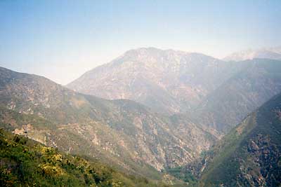
Looking northeast toward Iron Mt. (8007')
6-14-03 On the return trip on my hike up Shoemaker Road, I scrambled up the first section of the Rattlesnake Peak trail for this view. Notice the entrance to the second tunnel near the left edge of the photo. The trail cutting across the next slope over is the overgrown section, rounding the bend to end.
|
My hike for this Saturday was to explore Shoemaker Canyon Road and its "tunnels to nowhere." But I also had with me the trail description for the Rattlesnake Peak hike in order to scout it out for the future. After completing the trek to the end of Shoemaker Road and the half mile of additional bushwhacking, I headed back.
When I arrived at the junction for the Rattlesnake Peak route, I decided to explore it for a bit. This Rattlesnake Peak route side-track took me an hour and 12 minutes. It added an adventure dimension since the rest of the walk was on a road. The elevation gain (approx 450') up the ridge gave me a nice vantage point for views into the canyon and to the high country beyond. Worth the effort, but I would not do it again without long paints, gaiters, and trekking poles.
Related links on Dan's Hiking Pages:
Trail Links:
|
|