| |

 |
| |
|
| |
 |
| |
 |
| |
 |
| |
 |
| |
 |
| |
 |
| |
 |
| |
 |
| |
Dan's Hiking Pages: Hikes in the San Gabriels and Beyond |
|
|
Smith Mountain (5111')
Via Upper Bear Creek Trail
Hwy 39 / San Gabriel Gabriel Canyon North Fork
Angeles National Forest / Southern California
|
Trail Stats
|
|
Mileage (r.t.)
|
7.0
|
|
Trailhead
|
3290'
|
|
Saddle
|
4290'
|
|
Summit
|
5111'
|
|
El. gain
|
1825'
|
|
Gain per mi.
|
520'
|
Gain per mi.
TH to Saddle
|
333'
|
Gain per mi.
Saddle to sum.
|
1642'
|
This splendid peak sits at the heart of the San Gabriel Mountains on the ridge dividing Bear Creek canyon in the rugged San Gabriel Wilderness and North Forth Fork San Gabriel River. Its pointed summit provides an amazing 360 degree panorama. The first three miles of the hike are a pleasant walk from the trailhead at Highway 39 to Smith Saddle (4360') on a well designed single track trail that gains only 333 feet per mile. Your last half mile to the summit is a grueling 820-foot climb up a steep firebreak and boulder studded ridge.
In September 2002, the massive Curve Fire consumed 20,857 acres of mature forest and chaparral, including all of the terrain for your first three miles. The valiant efforts of the fire fighters kept the inferno from jumping over the ridge west into Bear Creek canyon and the San Gabriel Wilderness. Thus, as you stand on the ridge line you observe a very clear demarcation between burned and unburned. Over the years the burned area has recovered well, but the blackened, bare branches of oak and manzanita jutting above the green foliage are an enduring reminder of a very different past forest. The heavy storms in the years following the fire damaged the trail beyond usability. But through the efforts of the Forest Service and volunteers groups such as the San Gabriel Mountains Trailbuilders, the trail is once again in good condition and beckons hikers to trod its tread.
Season: October through June
This trail can actually be hiked all year long, but keep in mind that it can get snow in the winter and can be miserably hot in the summer. There is virtually no shade en route except from shadows from the surrounding terrain when the sun is low in the sky. My favorite season is the spring when the temperatures are mild, everything is green, and the wild flowers are at their best. View Seasons of the San Gabriels for a detailed description of minding the seasons.
Getting to the Trailhead:

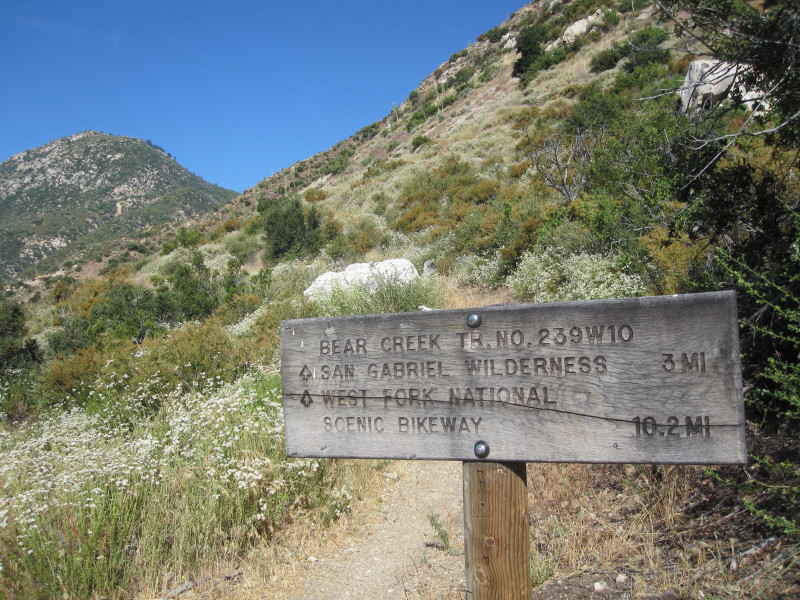
 From Interstate 210 in Azusa, take Azusa Avenue (Hwy. 39) north about 12 miles to the junction at East Fork Road (8.6 miles from the forest station at the mouth of the canyon). Continue straight on Hwy. 39 and drive another 6.2 miles to the parking area along the left side of the road (a quarter mile short of Coldbrook Campground). There is a vehicle gate at this location, and as of the date of the last page update, it is locked and the road is closed beyond. At the trailhead is a pit toilet, a San Gabriel Wilderness display sign, a forest service information sign, and a trail sign: "Bear Creek Tr. No.239W10." A National Forest Adventure Pass is required.
Trail Description:
 Walk to the north end of the parking area past the restroom and find the marked trail. The trail starts heading south paralleling the road for a bit. Then after a several switchbacks, the trail crosses over a small ridge and enters the first of two primary canyons en route. The summit of Smith Mountain looms high to the west. Across the canyon you can see your trail. Mile posts conveniently mark your progress. At about 1.5 miles, you transition into Lost Canyon. The trail crosses several places tucked into the wrinkles of the canyons hosting thriving oases of lush green plants and sycamores. Along the trail you'll see wood and steal retaining barriers. These are called "Sutter walls" and were installed by a trail contractor hired by the Forest Service in 2006. I think they are unsightly and would much prefer hand-built rock walls. But a least we have a stable trail. After three miles of hiking, you reach Smith Saddle (4290'). Walk to the north end of the parking area past the restroom and find the marked trail. The trail starts heading south paralleling the road for a bit. Then after a several switchbacks, the trail crosses over a small ridge and enters the first of two primary canyons en route. The summit of Smith Mountain looms high to the west. Across the canyon you can see your trail. Mile posts conveniently mark your progress. At about 1.5 miles, you transition into Lost Canyon. The trail crosses several places tucked into the wrinkles of the canyons hosting thriving oases of lush green plants and sycamores. Along the trail you'll see wood and steal retaining barriers. These are called "Sutter walls" and were installed by a trail contractor hired by the Forest Service in 2006. I think they are unsightly and would much prefer hand-built rock walls. But a least we have a stable trail. After three miles of hiking, you reach Smith Saddle (4290').
|
|
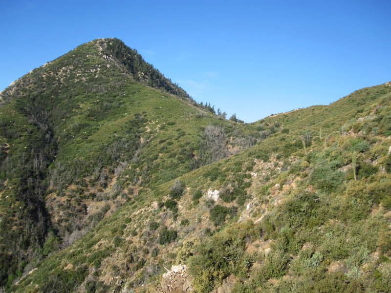
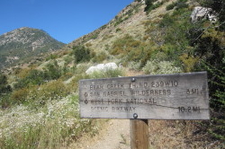
Smith Mt. and Smith Saddle - Looking southwest from Upper Bear Creek Trail. That ridge is your route. View Large Image
|
From the saddle you have three primary options. One is to return the way you came making a very pleasant 6-mile round-trip hike. Another would be to descend the trail west into the San Gabriel Wilderness another 2.6 miles to Bear Creek making for a substantial 11.2-mile round-trip hike with 2,900 feet in elevation gain. But to summit Smith Mountain, you will climb the steep firebreak heading south. The fire break ends at a steeper section—a jumble of rocks and brush—which you negotiate to achieve the summit, one half mile and 820 feet above the saddle.
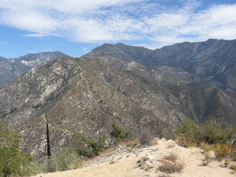
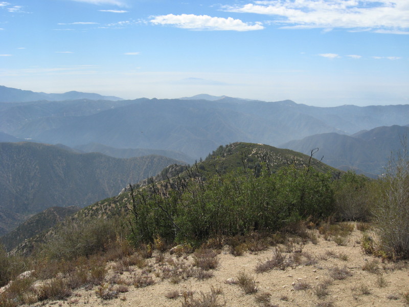
From the lofty peak of Smith Mountain you are rewarded with a stunning 360 degree panorama of the heart of the San Gabriels. To the west lies the rugged San Gabriel Wilderness, the pointed summit of Twin Peaks East Peak, and in the distance, Mt. Wilson and its neighboring peaks. To the south is Pine Mountain the various front-range ridges and summits. Hawkins Ridge dominates your immediate northeast, and further away is Rattlesnake Peak and beyond to the high country of Mt. Baldy, the Three Ts, and Ontario Peak. To the north is Windy Gap, Mt. Islip and Kratka Ridge.
After enjoying your perch, return the way you came, and take special care in negotiating the steep descent to the saddle. 
Hike Log
Smith Mountain
8-19-07
|
|
8:10 am
|
A: Trailhead (3290')
|
|
8:42
|
B: 1-mile marker
|
|
9:19
|
C: 2-Mile Marker
|
|
8:56/9:08
|
D: Smith Saddle
|
|
11:06/12:00
|
G: Smith Mt. (5111')
|
|
12:40/1:02
|
D: Smith Saddle
|
|
1:52
|
B: 1-mile marker
|
|
2:25 pm
|
A: Trailhead (3290')
|
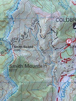
 View Large Map (212 K)
Tom Harrison Maps
|
|
|
Related links on Dan's Hiking Pages and Blog:
Links:
Book:
- Trails of the Angeles: 100 Hikes in the San Gabriels - by John Robinson (Wilderness Press). Hike 73: "Highway to Smith Mountain". Provides hike features and brief trail description. He puts the elevation gain at 1900 feet, which might account for some mild rollercoaster action.
Last Hiked: August 19, 2007 (summit) / November 6, 2010 (saddle)
|
|