| |

 |
| |
|
| |
 |
| |
 |
| |
 |
| |
 |
| |
 |
| |
 |
| |
 |
| |
 |
| |
 |
| |
Dan's Hiking Pages: Hikes in the San Gabriels and Beyond |
| |
|
|
|
ARCHIVE PAGE - Trail Closed
This page for HISTORICAL PURPOSES ONLY
Upon the opening of the new access trail on June 21, 2014, the old access trail climbing over Van Tassel Ridge has been closed as a route to Fish Canyon. This page stands as a slice of history describing the old trail. The portion of the trail connecting the national forest boundary on Van Tassle Ridge to Fish Canyon Trail remains open (the Alternate route at end of the hike description) (See first link below for new trail description).
Related Links:
|
ARCHIVE PAGE - February 19, 2014
Trail Closed - This page is for HISTORICAL PURPOSES ONLY.
|
Van Tassel Ridge via Fish Canyon Trailhead
Azusa / Los Angeles County / Angeles National Forest / Southern California
|
Trail Stats
|
|
Mileage (r.t.)
|
3.8
|
|
Trailhead
|
680'
|
|
Forest Boundry
|
2080'
|
|
El. gain
|
1400'
|
|
Gain per mi.
|
737'
|
This trail is the fruit of an ill-conceived and misguided plan. The trail, dedicated in 1999, was an attempt to provide an alternate route to Fish Canyon Falls to avoid the problems of access though the quarry, which sits in mouth of the canyon. The hike to the falls going through the quarry is a pleasant 5-miles round trip with only 900 feet of elevation gain. But the hike to and from the falls using the Van Tassel Ridge route is 8.5 miles with 3,200 feet of elevation gain—absolutely ridiculous! If you want to hike to the falls, the only sensible way to hike Fish Canyon is through the quarry, so you'll need to make arrangements with Vulcan Materials. See my Fish Canyon hike description.
This present hike takes you on an out-and-back adventure up Van Tassel Ridge. The first 1.4 miles of the trail is narrow, steep, eroded and rugged in places, and sometimes overgrown with mustard, thistle, sage, and more. The trail is poorly (if ever) maintained. It's simply a bad trail (See hike report - 5-1-03). The top part of the "trail" is mostly dozer-cut swaths up the slopes and ridges, some very steep.
|
|
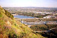
4-10-05 - Looking southwest toward the trail I just came up. What trail? Exacty! The San Gabriel River and Azusa are in the background. Large photo
|
But in spite of all its bad qualities, the trail does offer a doable route up Van Tassel Ridge, which would not be achievable any other way except climbing the quarry haul road (which is private property and off limits to the public). On a clear day, you are treated with splendid views out over Azusa, Duarte, and the east end of the San Gabriel Valley.
Season: November - May
Most of this trail is without shade and on south-facing slopes, so it can be grueling on a hot day. The winter and early spring are the best times to hike Van Tassel Ridge, when the brush is green and soft and less brutal. In the spring after a good rain, the blooming flowers can be quite nice. But watch out for ticks and snakes. I like hiking the trail at daybreak or at the end of the day. See Seasons of the San Gabriels for a detailed description of minding the seasons.
Getting to the Trailhead:
 From the I-210 Foothill Freeway, traveling west: exit at Irwindale Avenue in Irwindale. Turn right (north) and go 0.2 mile. Turn left (west) on Foothill Blvd. and go 0.7 mile to Encanto Parkway. Turn right (north).
From the I-210 Foothill Freeway, traveling east (or the I-605 traveling north): Exit Mt. Olive Avenue in Duarte. Turn right (east) on Huntington Drive and go 0.6 mile to Encanto Parkway. Turn left (north).
Drive north on Encanto Parkway. At 1.3 miles you'll pass the signed entrance to Encanto Equestrian Center, a dirt road going off to the left. In another 0.2 mile there will be a dirt parking on the left side of the road. Park here. No Forest Adventure Pass is needed since this hike begins outside the forest boundary. See street map
Trail Description:
 From the parking lot, follow the trail signs at the north end of the parking lot. In a couple minutes you'll pass the official trailhead with an information board and a sign-in box. Continue north along the base of the mountain and in a few minutes you'll pass some horse facilities on the right. The trail then makes a sharp left, heading steeply up the slope. You then turn back toward the south and follow as it winds and switchbacks its way up the mountainside. The sheer steepness of the slope offers some striking views directly down into the quarry, the trailhead, and the residential area to the south. After 1.3 miles you reach the ridge to the west of Diamond Head summmit (1603'). There is a trail which heads off to the right (east), but it dead-ends in thick brush in less than a 100 yards.
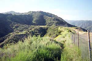 As you continue straight then down to the left into a little saddle, you enter what I call the jungle. It's a pleasant contrast from the brushy chaparral you just hiked. The trail gently descends through the "jungle" and contours along the west flank of Diamond Head, then ascends to the right (east). Watch out for the several threatening occurrences of poison oak. After 10 or 12 minutes from the Diamond Head junction, you arrive at a fence that runs north and south along side a quarry haul road. Follow the fence north (see picture on right, looking north). In a few minutes the fence ends and a wide bulldozer swath heads west up the slope.
Follow that route. In about 100 yards, a single-track trail veers left to circumvent the dozer cut. This is one option, The trail reaches a flat area on the ridge with nice views down into Van Tassel Canyon. It then turns north and climbs to rejoin the dozer swath. But that trail is not formally maintained, so use the trail at your own risk. The other option is to continue up the steep dozer-road (this is the route Schad describes—see Books below).
 Follow this steep dozer cut up the ridge until you reach a fence marking the boundary of the Angeles National Forest (1.9 miles from the beginning of your hike). Enjoy the views and rugged scenery of the front range and beyond Return the way you came.
Alternate route - If you want extend your adventure, you can continue on the trail past the boundary fence and zigzag down into Fish Canyon. I do not recommend this route as a way to reach Fish Canyon Falls, but if you are into adventure, you may find it interesting. Soon after you pass through the fence heading north on the ridge, the trail veers to the right and begins its steep descent, east. There are many switchbacks en route. In April 2005, the canyon slope was lush and green, almost jungle-like (fern, honeysuckle, scrub oak, laurel sumac, sage, poison oak). It does not look like there has been any trail maintenance in at least a year. I had to trim back a lot of poison oak to safely proceed. When I hike it in March 2010 I observed that there had been recent trail work and the trail was reasonably free from encroaching vegetation. Several times en route the trail intersects the ascending/descending ridge and offers some striking views south toward the quarry. After descending 1,000 feet, you reach Fish Canyon Trail. Now if you are glutton for punishment, you can return the way you came. Or if you turn left (north), you can hike 1.9 miles to Fish Canyon Falls (see my trail description). Or, turn right (south) and in a few minutes you'll reach the bridge which marks the beginning of Fish Canyon Trail. A locked gate and chain link fence restricts your entrance to the quarry. If you have made arrangements with Vulcan Materials, you can pass through the quarry and back to the trailhead (0.7 mile).
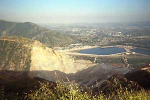
5-1-03 - Looking south on Van Tassel Ridge from the boundry of Azusa and the Angeles National Forest (2080')
|
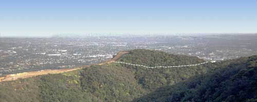
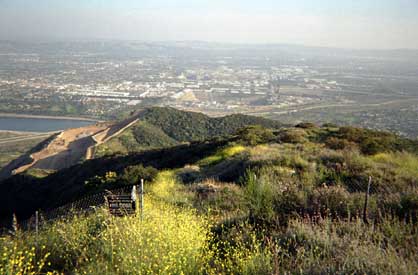
5-1-03 - Looking south at Diamond Head from a steep dozer cut which supposedly is a "trail." The dotted line shows the approximate route of the trail traversing the jungle-like area (this "jungle" is pretty withered and arid by mid to late summer).
Note: This is the section Vulcan plans to mine.
|
Trail Notes - Van Tassel Ridge via Fish Canyon Trailhead:
- Long pants are recommended.
- Trail Condition Update - 2-15-14 - The trail to Diamond Head ridge was in reasonably good condition but eroded in some places. Plants were not intruding into the trail and I was quite comfortable in shorts. With our record-low rainfall, the vegetation looked parched, making it feel more like August than February. There was virtually nothing in bloom. The steepness, loose trail surface, and climbing down rocks made going downhill tedious and slow. See my whole blog post.
- Trail Condition Update - 3-31-12 - The trail was not terrible but it's still not great. Brush squeezed the trail. Lot of ticks. Steep. Loose footing and deteriorating in places. Lot of poison oak in the "jungle" invading the trail. Wildflowers in bloom added a nice splash of color. The poor design of the trail was more apparent going down, climbing down rocks and steep steps. Foggy day, limited visability. See my whole blog post.
- Diamond Head - Upon achieving the ridge at 1.3 miles, a side trail breaks off right (east) toward Diamond Head summit (1603'). I've tried several times over the years and always found it to dead end into heavy brush in less than 100 yards. On 3-31-12, I achived Diamond Head summit coming from the north but could not find a route west to meet the trail. I had to climb through thick brush.
- The trailhead, just north of the parking area, has sign-in book and nice information board. Unfortunately it's covered with a heavy mesh wire making it hard to read.
- The Jungle - From the summit fork to the quarry fence, the trail drops east into a little saddle and around the east flank of Diamond Head. In the spring, it's jungle-like and pretty, a pleasent contrast from the rest of trail. However, by August its pretty withered and arid and ceases to be pleasent. Watch for poison oak. Thistle is painful too.
- In Azusa - Robinson and others cite this trail as starting from Duarte, when in actuallity, it is within the Azusa city limits.
- Upper Ridge - At 1.9 miles up Van Tassel Ridge from the trailhead, the trail passes through the fence marking the border of the Angeles National Forest (2080'), then starts its descent into Fish Canyon. On 8-14-04, Albert and I explored further up the ridge looking for an alternate route to Mount Bliss. The brush—primarily buckwheat, chemise, sage, and some scrub oak—is thick and scratchy. It was obvious that others had gone that way, but there had not been enough traffic to make the route easily passable. After about 0.2 mile we achieved the highpoint on the ridge labeled 2364' on the topo map. The vantage point offered some nice views down into Van Tassel Canyon. However, to forge up the ridge further would take considerable effort, thrashing through the unforgiving chaparral. And from that point we could see that there was not a clear route to climb the steep pitch to the high point labeled 3136'.
Related links on Dan's Hiking Pages:
Van Tassel Ridge / Fish Canyon Trail Links:
Books:
- Trails of the Angeles: 100 Hikes in the San Gabriels - by John Robinson. Hike 49: "Duarte to Fish Canyon, Fish Canyon Falls." Trail descriptions with historical background. In his 7th Edition (Sept. 1998), Robinson adds the route going up over Van Tassel Ridge to the falls: 8.5 miles round trip, 3,200 feet elevation gain. Also in the 7th Edition, he (or an editor) mistakenly sets the season as "All year" whereas previous editions have the season as November through May. This is a bad mistake. You don't want to go up the Van Tassel Ridge route in the hot season. It would be terribly punishing! Unfortunately, they did not correct season error in the next edition. In the 8th Edition (April 2005), with Doug Christiansen, they promote the Duarte Family Wilderness Day in April as the primary option for hiking to Fish Canyon Falls, but the event no longer includes a hike to Fish Canyon Falls through the quarry. They also include the description for the Van Tassel Ridge route, but rightly call it "tortuous" and "definitely not recommended."
- Afoot and Afield in Los Angeles County - by Jerry Schad (Wilderness Press: Berkley) - Area B-9, Trip 3: "Fish Canyon Falls." Good trail description using Van Tassel Ridge to access the falls trail. He places the round trip distance to the falls at 8.8 miles with 3,100 feet elevation gain. He describes the hike over Van Tassel Ridge as a "devilish climb."
- Los Angeles County: A Day Hiker's Guide - by John McKinney (The Trailmaster, 2006). "Fish Canyon Falls: Fish Canyon Trail." Good trail description using Van Tassel Ridge to access the falls trail. He places the round trip distance to the falls at 9.0 miles with 1,200 feet elevation gain (neglecting to factor in the return trip). His details are a little scant and he mentions a couple things that are no longer present: an old rust water tank and the gun club, which closed in 2005. He states that "The first half of this hike is nothing less than horrible."
Last Hiked: March 31, 2012 - To forest boundary
Last Hiked: February 15, 2014 - To Vulcan fence near Diamond Head
|
|